Why Design Matters, San Diego! North Park Community Plan Update Issues

Climate Action Plan, San Diego, Urban Design, Urban Planning

For the past 4 or 5 years, I’ve been working on the North Park Community Plan Update for the North Park Community Planning Group, and here at the end it simply is not achieving the goals the community set out to accomplish when the project started 8 years ago. The three issues I have with the North Park Community Plan Update (CPU) are:

1) Any up zoning beyond our 1986 plan that enables 2016 mixed-use, walkable urbanism on Transit Corridors necessitates an expensive + time consuming Planned Development Permit/Process 4. We wanted to focus, encourage, and make easy new development on El Cajon Blvd – ECB;

2) Dismissal of requested Historic District Designations in older bungalow neighborhoods that need/want the discretionary review mentioned above for ECB as local ‘preservationist’ agreed to this compromise as we intended to give additional protections and make it harder to bungalow neighborhoods, and;

3) 1960s city-wide zoning replaces 1986 local zoning and both still enable new single-story/use drive thrus (new Starbucks, Wendy’s, Sonic as examples) on ECB by-right and easier than vertical mixed-use buildings (this shift was a big deal to build more housing and shops in NP).

b6362c88-b3b4-4325-bec7-db6295318925

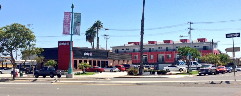
New mixed-use housing… a full lot OFF University Avenue (a Main Street)

f4fb5c79-acc2-4008-a77f-f13626911c63

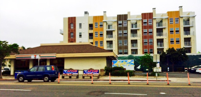
New development on El Cajon Boulevard… again note the drive up chain food with urban housing a full lot OFF the main boulevard. This is the predominate pattern.

I will post my PEIR issues at a later date…

So, Community Plans are only used to review discretionary process as zoning does the heavy lifting to build San Diego. You have a zoning designation on your lot now and to change that takes discretionary review. So, status quo has been maintained and all of the new policies written into the CPU are only reviewed on those few projects requesting changes. The problem is we have now made new development on ECB more difficult than new development in our bungalow neighborhoods.

It is important to know that San Diego zoning does not have to be in conformance with its policies b/c we are a Charter City. This makes our City of Villages big idea near impossible to Implement. And, we didn’t upgrade/change any of our zoning from 1986 all we have essentially maintain status quo with this CPU.

image-1-7

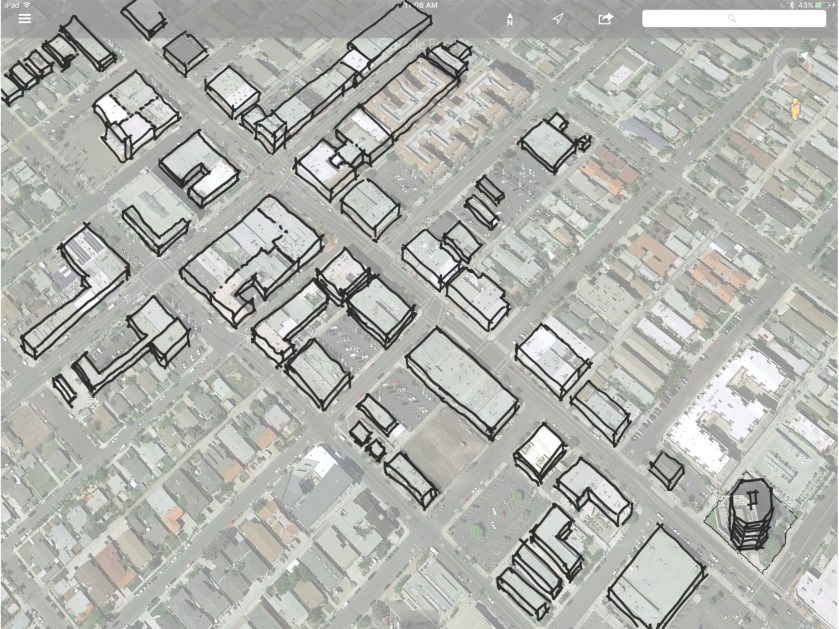
Existing Zoning on University Avenue and 30th Street, the Village ‘Center’ of North Park.

All of our zoning is based on 1960s suburban community building tools and is built on segregating Land Uses from each other (Residential/Commercial/Industrial) and is difficult to use to build mixed-use, walkable urbanism (think about the difference in vertical mixed use in older east coast cities versus in newer southwest cities).

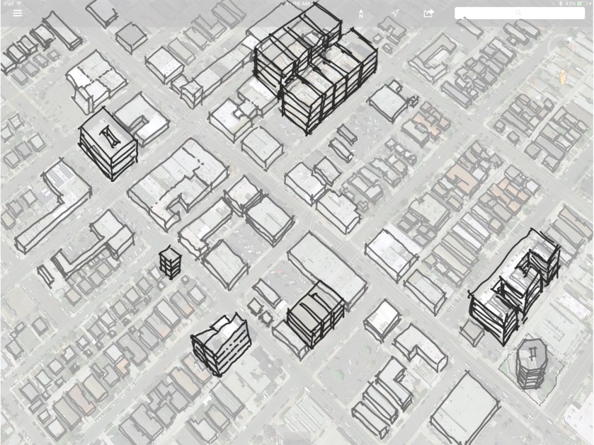
The best example of how our single-use zoning doesn’t implement the type of contemporary city we want is found near one of our obvious Transit Village Centers at University and 30th Street. This could be either the next great place or Another PB or College bar scene.

image-1-5

Existing Commercial Buildings, some historic, most just stucco boxes. My Grandmother worked the Woolworth building in the center and lived three blocks away.

image-1-6

Existing Residential buildings, with many historic bungalows here and more just off image.

Today, our best vertical mixed-use walkable building’s are a half-block off University (La Boheim, You’ve Got Mail, New Senior Housing, and Parking Garage) b/c University is zoned heavy commercial and the neighborhood behind is zoned heavy residential. But planners knew that a transition was needed, so they made very flexible zones to allow either commercial or residential or some of both… which put our best urban buildings closer to historic homes than ON the transit corridor. Almost every new building is OFF the night street (crazee burger, CWH on Texas & Howard) b/c of this vert good mistake.

image-1-3

Our recent and best new mixed-use, 4-6 story buildings are all just OFF University Avenue, and deeper into the historic neighborhood, making local NIMBY opposition more heated.

image-1-2

This is what have and are continuing to build today…

How to fix this?  Well, it is too late to fix in the Community Plan Update, but the Land Development Code is updated annually and zoning is the key to success anyway. So, I recommend using a Zoning Overlay, or a Place-Based, Form-Based, context-sensitive zoning tool to achieve the overall density within 600-feet of major transit station areas to shift or mode of transportation from predominately autos to walking, biking, riding transit, and cars. Here is what the results could deliver:

image-1-1

More housing/jobs bang for our transit buck and all ON University Avenue, staying out of the neighborhoods that’ll add housing with state-mandated  Accessory Units (Granny Flats)

image-1

Place-Types identified and coded accordingly: Core – I / Center – II / Edge A – III / Edge B – IV / Historic  – H/ Civic Space – P / Residential – V

Why Design Matters, San Diego! The Cabrillo Bridge + Plaza de Panama

Public Space, San Diego, Urban Design

Way back in 2010 I asked the City of San Diego Planning Commission, “Why screw up the bridge to fix the plaza?” Six years later it still rings true as it makes very little sense to significantly alter/change one of San Diego’s best places, the Cabrillo Bridge, in order to remove the few cars now flowing through the now beloved Plaza de Panama. Back then, the project passed our city council amidst volatile debate and subsequently failed a court challenge. Very few cried its demise. Mayor Sanders and beloved philantropist Dr. Irwin Jacobs walked away from their “all-or-nothing pedestrian-oriented plaza Centennial Plan” that consisted of an auto-oriented ‘by-pass bridge’ appendage off the Cabrillo Bridge that funneled traffic into a 200-car parking garage. However, last year the lawsuit was overturned and the exact same project was quietly resurrected by new Mayor Falconer.

bpposter

A ‘World’s Fair’ with the same design intent as Chicago’s White City and London’s Crystal Palace.

Three years ago, a group of us assisted Mayor Filner (curse his name) to design a temporary pedestrian plaza that has been a clear success (for 60 plus years it was a parking lot for 57 cars).  It was a ‘tactical urbanist‘ approach to test and measure success before investing in such a dramatic change in its character from a parking lot into the plaza it was designed to be. We had to be mindful of local institutions fear of losing customers (all have since had record breaking years) who would want to park in front of their museums as well as the Uptown Planning Group not wanting people to park in their community if the bridge was closed to all traffic. The plaza sits on an isolated mesa and as design icon Leon Krier noted, the plaza core needs traffic to bring people to it as nobody lives in easy walking distance, which makes it very different from European city plazas in the center of town (Plaza San Marco in Venice, Piazza Navona in Rome, and Rittenhouse Square in Philly).

pdpbeforeafter

7/8th of Plaza was re-opened to pedestrians, replacing 57 parking spaces, but still allowing cars and trams to flow through 1/8th of the plaza to pick up/drop off.


The Problem

The new by-pass project looks like any other auto-oriented grade-seperated off-ramp leading to a parking garage between Sabre Springs and Riverside. The design is an after thought, breaking the flow of one of the world’s best designed places found in San Diego (the other might be the Salk Institute).

plaza-de-panama-plan

Rick Engineering and Civitas Design for the Auto By-Pass + Parking Garage (on right)

balboaparkbypassbridgerendering

I’m not sure what to write here… except that this is exceptionally underwhelming.

My concern is that the poorly conceived, traffic engineering focussed space that will scar our Panama Exposition core as every other building, street, plaza, park space and parking space in it was executed with tremendous design acumen over a century ago for our pleasure. What will be beloved about this new appendage a 100 years from today. It appears we are honoring our cultural heritage with what will now be two new dreary parking garages (the other is between the Botanical building and the zoo) and a ‘by-pass’ that diverts people away from intended beauty and into an enclosed parking lot.

not-impressed-comment-meme

Okay, a bit dated, but so are the issues at hand.

Unfortunately, San Diego has again forgotten what, Bertram Goodue, and George and Hamilton Marston knew: Building towards social and cultural value always equates to economic value while the converse is not always as true. Point is, we need to design in ways to celebrate, exhaust, express our local cultural values… maybe the by-pass does this?

I understand the construction documents are currently under review in the city’s Development Services Department, so this is essentially a moot point. I’ll go on as an explanation for posterity purposes, and thank you for continuing to read this…

The Original Big Idea

In my century old edition of Carleton Winslow’s, The Architecture and the Gardens of the San Diego Exposition, master architect,  Bertram Goodhue, clearly explains Panama Exposition’s big design idea. His metaphor was to give visitors to San Diego a virtual tour of traveling across the Atlantic Ocean (The Cabrillo Bridge); Through the Panama Canal where the Atlantic and Pacific Oceans collide (California Quadrangle and its California Tower as a beacon); Up the Mexican Rivera coastline (the Spanish Arcades), and finally; A majestic arrival at a new California Arcadia (The Plaza de Panama)… all set in a ‘garden!’

goodhuebigidea

Goodhue had a darn good idea, executed it well, and let everyone experience what the Panama Canal means to San Diego and its beautiful, well-designed future!

img_0331

The View of the By-Pass Bridge area as conceived by Goodhue. These buildings are suppose to be in a garden setting, and not a parking lot.


quadcanal

The two reclining figures represent the Atlantic and Pacific oceans with the waves colliding at the Panama Canal in the center.

Three Better Design Options:

1. Shared Street: Keep everything as is… and rather than build more auto-oriented facilities (by-pass bridge + 200 space parking garage), a more  austere solution would be to make the street a ‘shared space,’ and keep the traffic flow to minimum speed of bikes and pedestrians with valet drop off, in order to access and enhance – rather than alter – San Diego’s greatest civic space. Everyone wins, even the parking garage can be built, and the cars/trams will behave even better, while continuing to deliver people directly to and from the institutions, and it only takes the cost of a sign. Supporters of the Sanders/Faulconer plan say the traffic today is dangerous. This would improve that for essentially $250 dollars (the cost of five signs).

sharedsignfinal

We already have these in San Diego (at the Mouth of the mighty San Diego River).

2. Use the Existing By-Pass to the Existing Parking Garage: Irving Gill, another great designer, already built an arcade portal that links to the north that needs just one short connection to access existing streets and an existing subterranean parking structure. Add 200 parking units (one deck) to the existing structure, make that one connection, and viola! A well-designed By-Pass that drops the elderly and patrons direction in front of the Theaters. Supporters of the Sanders/Faulconer Plan say they want the access/parking for the theaters and the core… this is closer, cheaper, faster. (Post-script: Heard the Quince Street off-ramp could be a better solution for this access point and should be discussed)

ByPassExisting.jpg

Two ways to access a parking deck and maintain the integrity of Goodhue’s masterful design: Through the Gill’s driveway or up from Quince Street)

quadranglecanal

See Irving Gill’s one-way By-Pass arch there on the left? Just signage and paint and its better designed than the engineering Sabre Springs off-ramp.

3. How about a Beautifully Designed Bridge: Propose a new addition that carefully and thoughtfully adds dignity, value, and delight to visitors biking, walking, tramming, or driving to visit the Panama Exposition Grounds. Simply host a design competition. Ask the best in the world to give their best ideas, be bold and transparent to San Diegans about the value of the place that we all love and care for! I have never understood why a world-class design competition has been avoided from the beginning and this project being handled in this ‘my-way-or-no-way’ manner?

The design issue is, beyond its mindless deconstruction of the Nationally Registered Historic Cabrillo Bridge, the banal by-pass bridge in a sea of beauty that purposely impedes the flow of Goodie’s original design idea while adding nothing to the culture and heritage of San Diego’s most recognized jewel. Well, now we can hope for the best as we have zero assurances the best is being considered a century after our forefathers delivered such for our benefit.


img_0333

Think this Bridge is Important to our Heritage? “Its more than a Bridge…”


The New Town of Whitehall

Urban Design, Urban Planning
[Prologue: Yes, I know this is a bit too aspirational, maybe a touch over the top, but I wrote what I felt so it must be true to some degree… and admittedly, a bit of ego is involved as I had a small hand in the making of what I believe is a great place, The Town of Whitehall. This new Town, and its neighborhoods is being constructed today in New Castle County, Delaware, and is founded by Brian DiSabatino (development manager) and Rich Julian (builder), with the help of my former firm, PlaceMakers, Robert Gibbs, Steve Mouzon, Mike Watkins, and many others.]

Whitehall was envisioned eight years ago on a 2nd story corner design studio located in a historic brick building in downtown San Diego. It came from a rudimentary understanding that small town culture was dependent upon the conception of balancing nature with our daily needs. Instead of forming a single and isolate subdivision of housing or commercial strip center shops that disregarded the surrounding landscape’s natural setting, Whitehall was organized as a variety of streets, blocks, houses, shops, schools and squares set within the beautifully Delaware’s timbered countryside. The master plan illustrates how streets radiate deep into a neighborhood defined by streams and woodlands that becomes a transcendental experience when the fall colors turn.

(The first idea is on the left; the plan today is on the right)

For this vision to becoming a built reality, New Castle County’s conventional suburban subdivision development policies and zoning regulations were updated to offer an alternative to reflect this long-standing neighborhood-to-nature interdependence upon which the character of each neighborhood is complete. Whitehall’s neighborhoods are being built as a 3-dimensional form of our spiritual and material worth expressed. The town expresses our collective values in how we choose to live our daily lives. It’s dignified, it’s flexible, and it accommodates everyone. This is a choice. To live in a city, town or neighborhood is not an accident, but the result of a coherent vision that built old New Castle, and the newer Kentlands, and King Farm, Maryland.

Conceived in the long-standing tradition of town building as a series of neighborhoods that coalesce into a new town over time, the interactions of neighbors, residents, visitors, and those who are ‘just passing by’ will build both past memories and future expectations that will shape the town’s eventual ‘community character.’ The design team understood that this traditional place making pattern brings people together while also siting lightly on the local landscape. These traditional urban design tools were used in order to build upfront a comfortable ‘sense of place’ to be accentuated over time with specialty and civic buildings as citizens move in, engage, and shape their built environment to their collective values. It also respects the existing neighbors to the east and doesn’t impede on their choices and built expressions, and the new highway will provide access to the region in need of towns, and districts, and forests, and bays.

Yes, Whitehall is personal and it is yours. And it is your choice to live and prosper in close proximity to your neighbors, shops, schools, and nature. Your parents auto-oriented status quo is shifted back to being human-oriented by this purposefully natural living arrangement as we have been expected to just get in our cars and drive to and from our homes, shops, schools, squares and parks without question. This new/old arrangement of streets, squares and buildings within walking, biking, scootering, hop-scotching, strolling and driving questions status quo as you choose to make your home personal, which matters if you care enough to change conventional expectations of how you live your life.

(New Mixed-Use Building, Mike Watkins is the consulting Town Architect)

whitehall_mixed-use-copy

The place we live in, grow up in, remember, and the culture that is cultivated in these sorts of places matter to our lives. As where you choose to spend time, which is all we really have in this world, comes a tremendous cost and forms the heritage we leave behind. Whitehall has purposely turned the chaotic, drive-by, unfulfilling auto-oriented lifestyle around to offer a more connected, comfortable, and convivial neighborhood setting to make with it what you will. You can go to school, or a shop, as well as drift off into the woods. This is a recognizably different set of promises built on the idea that the quality of our lives hinges upon our free choice and not upon the fate of those before us.

And then yet you will find Whitehall.

[Epilog: Ok, I stole that last line from Makaha Sons of Ni’ihau (Mickey Ioane), Hawaii ’78 protest song, which is one of the greatest protest songs ever written about people’s feeling about sacred land. While not beloved yet, as it will take time for citizens to transfer its character from its initial ground breaking. Whitehall is in its essence a protest statement against not being coerced to spend our valuable time and money on things and places that mean nothing to us. Our endless miles of cars, highways, gas stations, parking lots, driveways, turnpikes, 7-11’s, Applebee’s, Olive Garden, Starbucks, drive thru garbage food, etc…]