“Just Get the Ground Floor Right…” Modernisms Last Stand

Urban Design, Urban Planning

It was Luxembourg’s Leon Krier whose transformative polemic in the 1970’s and 80’s shaped America’s New Urbanism of the 90’s and 00’s and our reformation of traditional mixed-use, walkable, urbanism today. I’ve watched my city take baby steps from outlawed urbanism (’60s single-use zoning), to downtown sub-urbanism (’80s drive-thru Jiffy Lubes), to ‘safer’ Vancouver urbanism (’00s single point towers surrounded by suburban townhouses). And, over these 40 years this one truth has been drummed into our downtown urban design consciousness, “just get the ground floor right” and everything else will be fine.

Leon Krier's Studies of Traditional Urban Patterns has Decidedly Influenced our Cities of Today (Image Courtesy of LKrier)

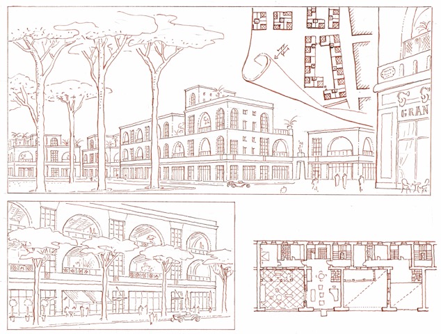
Leon Krier’s Studies of Traditional Urban Patterns has Decidedly Influenced our Cities of Today (Image Courtesy of LKrier)

So, we’ve stopped clipping the traditional, walkable, grid with new freeway off/on ramps. We are returning fast, one-way streets leading to those freeways into more humane, shopping promenades. We’ve added streetcars, jitneys, car and bike share stations, and protected bike lanes to help us get around. Small parks, plazas, and parklets spout up in vacant lots and street corners to slow us down and smell the coffee and craft beer. We are seriously endeavoring to repair our urban street pattern with infill redevelopment projects filling in and firming up our street walls as this interface supports the vitality and exhilaration of being downtown.

With this 2-dimensional base being well laid, downtown agencies are successfully getting new developers to build their 3-dimensional building’s ground floors in a more humane manner. The market supports this trend and every project’s ground floor has clear window shopfronts, and detailed transoms and awnings have returned with restrained signage, public restrooms, and shops spilling out onto the sidewalk. And nobody dares to dispute getting this first ground floor layer right. The 2D traditional urban street pattern has crept up to shape the 3D base of new architectural design… again, in a more traditional, humane manner.

New Ground Floors that Work (Americana - Rick Caruso)

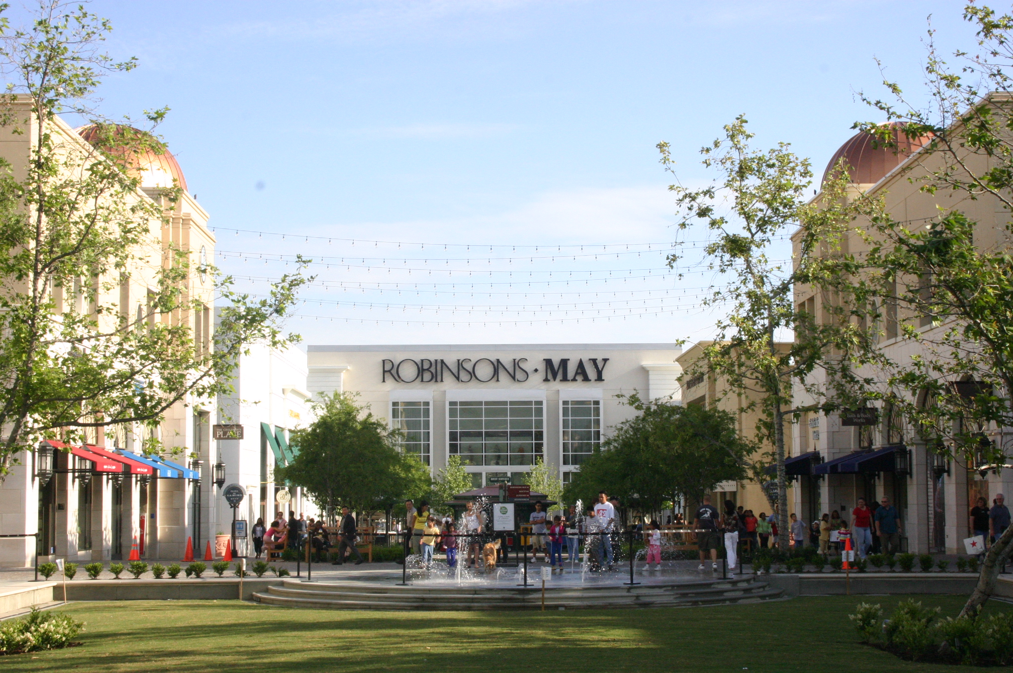
New Ground Floors that Work (Americana by Rick Caruso)

Rebuked Modernist Ground Floor Ideal ('39 Expo Futurama)

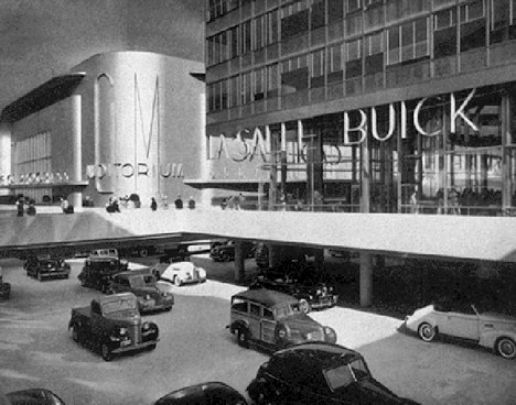
Rebuked Modernist Ground Floor Ideal (’39 Expo Futurama – Wikipedia Image)

And, here is where we find the last bastion of of the modernist architecture… fighting for survival in the materials, shapes, forms, and style of the building’s upper floors. Garish, look-at-me architecture still reigns in this narrow 25 to 140 feet range above the ground floor.

Seen This Proposed for Your Downtown Yet?

Seen One of These Proposed for Your Downtown Yet? (Image: LA Streetsblog)

I find it interesting that modernism has evolved from being a very big idea, to its ubiquitous mid-century development standard, to its now marginalized position between the ground floor and roofline. I completely agree with Witold Rybczynski that modernist architecture fits best in a natural setting, as well with Leon when it sits in juxtaposition to traditional architecture and urbanism.

Bilbao's Big Idea Wasn't,

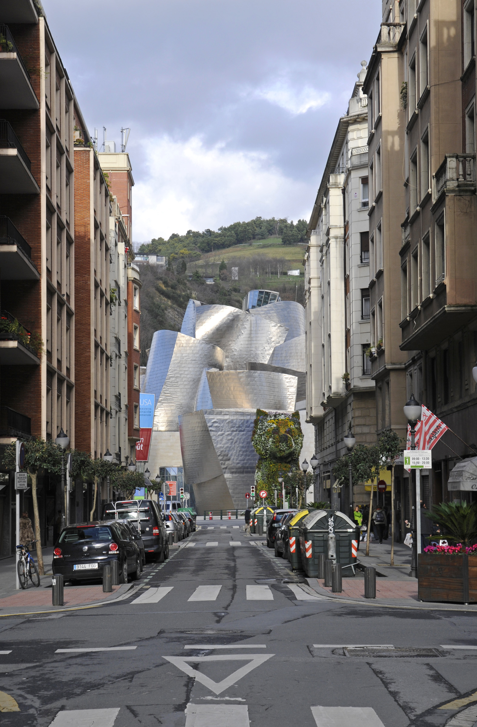
Bilbao’s Big Idea Wasn’t, “Hire a Starchitect!” It was Learning How to Architecturally Tune a Place to Create Visual and Cultural Complexity! (Image Unattributed)

John Nolen, San Diego’s original urban planner, once wrote in 1907 that city planning finds, “A place for everything, with everything in its place.”  Having been tested and vetted over three generations, maybe modernist architecture has finally found its appropriate place in our everyday life… within a very narrow range pushed as far away from people as possible.

Good Riddance! (Image by HBlackson)

Good Riddance! (Image by HBlackson)

Stand in the Place Where You Live… Being Context-Sensitive

Uncategorized

My latest thoughts on Context-Sensitive Thoroughfare design…

Howard Blackson

Every city and town are formed by its neighborhoods, districts, corridors, and its downtown. Each of these place types range from a more urban extreme, such as downtown, towards its more suburban, rural, or natural boundaries. And, each of these include a broad spectrum of public and private functions and places.

Looking in more detail, each neighborhood has its own set of more urban centers, general areas, suburban, and rural edges. For example, in my San Diego neighborhood, our center is the 100% shopping corner with coffee shops, boutiques, bars, mixed-use buildings and bus stops. And, my neighborhood boundary is formed by canyons and Balboa Park. In between are a variety of housing types ranging from garden apartments, bungalow courts, and small lot homes nearer the center to large lot homes along the canyon edges.

Single-use districts are places of industry, education, and regional institutions. These include airports, hospitals, and military basis. I tend to put suburban sprawl in…

View original post 339 more words

Stand in the Place Where You Live… Being Context-Sensitive

Urban Design, Urban Planning

Every city and town are formed by its neighborhoods, districts, corridors, and its downtown. Each of these place types range from a more urban extreme, such as downtown, towards its more suburban, rural, or natural boundaries. And, each of these include a broad spectrum of public and private functions and places.

Looking in more detail, each neighborhood has its own set of more urban centers, general areas, suburban, and rural edges. For example, in my San Diego neighborhood, our center is the 100% shopping corner with coffee shops, boutiques, bars, mixed-use buildings and bus stops. And, my neighborhood boundary is formed by canyons and Balboa Park. In between are a variety of housing types ranging from garden apartments, bungalow courts, and small lot homes nearer the center to large lot homes along the canyon edges.

Single-use districts are places of industry, education, and regional institutions. These include airports, hospitals, and military bases. I tend to put suburban sprawl in these single-use districts with their ubiquitous pods of housing and strip centers, and nary shall the twain meet.

A city’s corridors are either natural, such as rivers, beaches and protected habitats, or urbanized, such as railways and thoroughfares. Thoroughfares may link one side of the city to the other, or one side of a neighborhood to another, and often change character as they transition from downtown, through older streetcar neighborhoods, and finally to a city’s suburban edge.

01-intro.indd

Neighborhood Core, Center, General, and Edge Areas (Image by DPZ and Center for Transect Studies)

These thoroughfare corridors are made up of two main elements: centers at key intersections and those segments in between. Thoroughfares may range from well-connected primary streets to less-connected secondary streets. Their centers may range from more intense vertical mixed-use, on at primary cross streets, to less intense horizontal mixed-use at secondary street intersections. A corridor’s intensities and patterns depend upon if they have service alleys and lanes or not, and/or if they have rigid gridiron pattern, a curvilinear network, or are auto collecting arterials in a dendritic hierarchy of streets from freeways to cul-de-sacs.

Intersections have differing intensities depending on street type(s) and number of connections.

Intersections have differing intensities depending on street type(s) and number of connections.

All of which means that context matters.

Using place type elements begins a context-sensitive approach to place-making allows for both understanding the existing conditions, such as discerning if the site is on a primary avenue in a downtown neighborhood or on a secondary street in a suburban residential district, as well as being able to plan for the most appropriate design intervention if it is located in an older streetcar neighborhood with rear alley access. And with that said, a well-connected street will change its character over many miles.

In short, general thoroughfare types range from Highways (connecting regions), to Boulevards (connecting cities), to Avenues (connecting neighborhoods), to Streets (connecting blocks), and then to Alleys (connecting lots).  Each of these support a variety of transit, bicycle, pedestrian, car facilities. By understanding a corridor via its place and street type proponents can use this context-sensitive approach to retrofitting our auto-dominated streetscapes, as well as to explaining changes to local stakeholders and decision-makers (I hope…).

Avenue Plaza 2

Seattle Retrofitting and Transforming its Streetscapes.