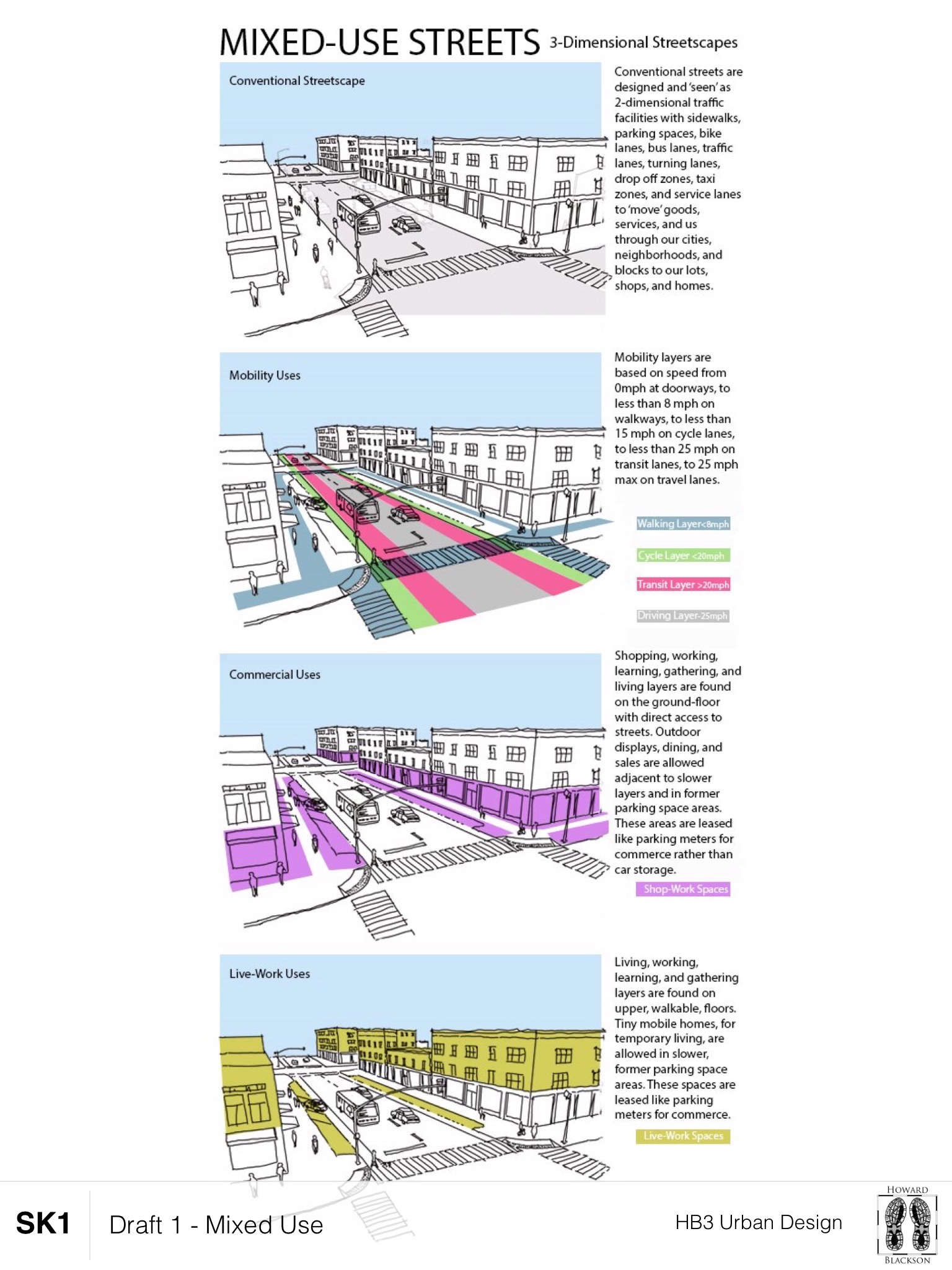
Streets have a mix of uses. Streets needs to be viewed in terms of a series of layered uses and speeds and be designed appropriately in relationship to the buildings that front onto the streets. The following are a list of uses per layer from building edge to centerline:
1) Ground floor Layer – The building fronting onto the street. Hold long-term Commercial, Residential, and Civic uses.
2) Encroachment Layer – Holds signs, less than public seating, dining, displays, deliveries, doorway zones. Holds more longer-term Commercial, Residential and Civic uses.
3) The Sidewalk Layer – <5 mph pedestrian travel lane with walkway, ADA access, on a clear path.
4) Furnishing Layer – Street Tree planters, more public seating, street lights, signage, parking meters, newspaper stands. Holds longer-term Commerce uses.
5) Parking Layer – Public parking stalls (angled/parallel/perpendicular/reverse angle), painted stripes, handicap stalls, transit stops, loading/commercial zones, drop off/delivery, and short/long-term car storage. Holds more shorter-term Commercial, Industrial, and Residence uses.
6) Cycle Layer – <10 mph zone between stopped parking cars and transit/travel lanes for various cycles ridden by various aged people.
7) Transit Layer – <25 mph zone between pulling in/out of Parking Layer and into the Driving travel through lane(s).
8) Driving Travel Layer – <25 mph zone (because any more than that kills most people)
All of these layers are mostly interchangeable and not every element is on every street. The big idea here is to introduce to the Furnishing and Parking Layers permanent Parklets, and movable/temporary Tiny Mobile Units in place of private car storage. These facilities can be rented and used for metered time periods as shops, hotel, and short-term residences. This is a shorter than permanent building Live-Work mix of uses that sit in the public right-of-way and reclaim the street from primarily auto flow use to a more livable and complex area that prioritizes the speed and scale of people. The image is an unfinished draft.
A forthcoming Mixed-Use Street PROPENSITY Map will illustrate where the more to less mix of uses on the streets are located. Think of it like a land use plan map for our streets. And, finally, for cities and places with overly scaled streetscapes, this is a way to reclaim public space for private commerce and housing (some public). A link to the ratio of public to private space discussion is here. What do you think?