Horton Plaza Needs More than Another Single-Use

Uncategorized, Urban Planning, Urban Design, San Diego

San Diego Architecture Foundation’s annual Orchids and Onions event awarded Downtown San Diego’s vacant Horton Plaza (HP) Shopping Center an Onion last fall. HP is out-of-date and unworkable, obviously. And this is true any half-vacant shopping center or 1960s office strip center throughout the nation. HP was built specifically to be an open-air, enclosed mall and it was very successful from 1980 to about 2010.

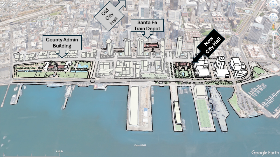
The demand for suburbia is over at this time (don’t worry, it’ll come around again in 10 years or so). While HP is not the only vacant mall trying to reinvent itself in San Diego (see slide 5 below), it is our region’s most urban/downtown one and has the same issues as any suburban retrofit project. The best mall re-invention solutions are to reestablish connections to streets/blocks currently closed and add housing. Simple, right?!? Well, it’s not as those two interventions involves the local municipality (streets/utilities/regulations), new development partners (multi-family), different lending models, and policy/regulatory updates, and building code conflicts.

It is not impossible, as Belmar in Lakeland, CO, is hands down the best retrofit and Horton will have to do the same mixed-use, connected redevelopment to be successful again.

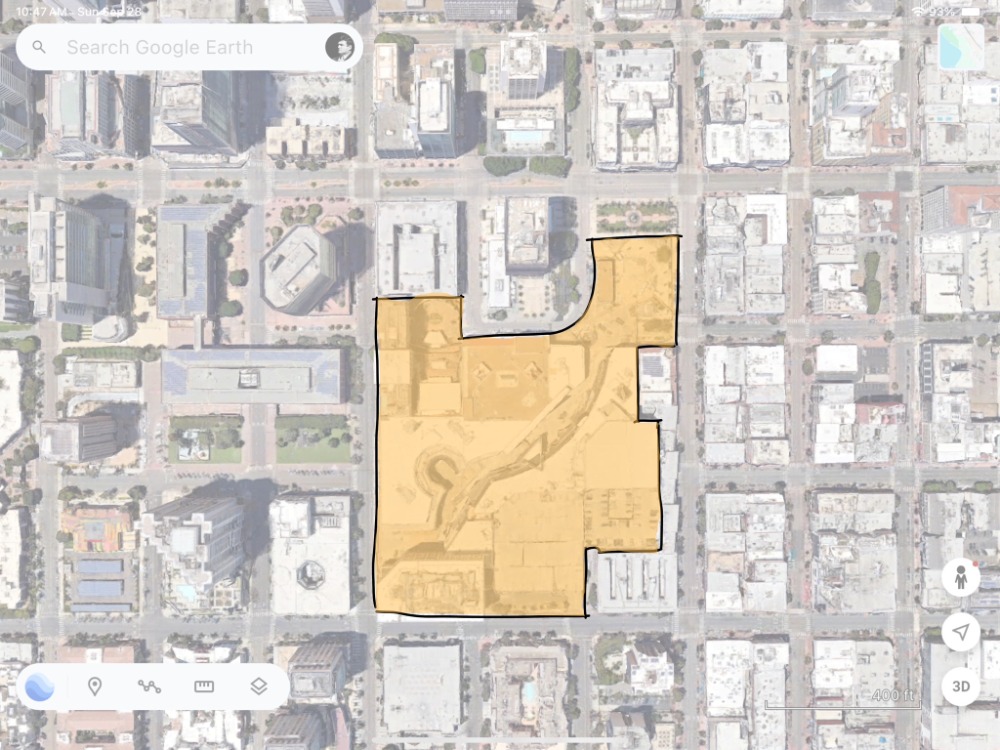
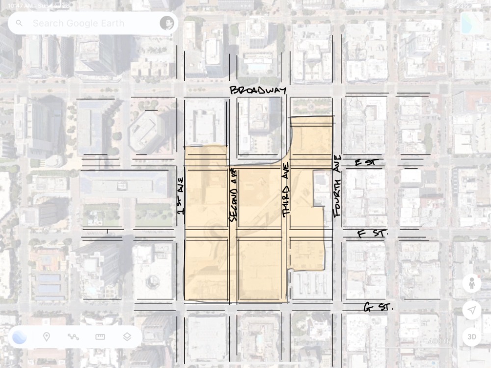
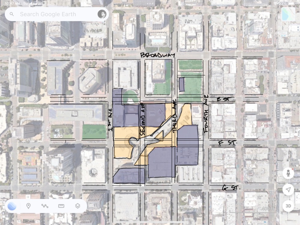
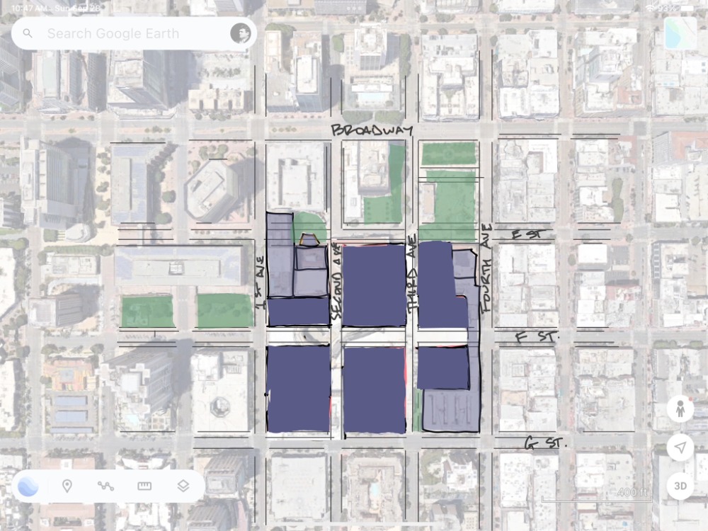
45-years ago, HP was the first return to downtown urbanism. But it was a baby-step, still suburban, and built for one private shopping center model at one point in time, and it worked for 30+ years. So, to retrofit, first, the city’s downtown code enables mixed-use. However, reconnecting closed streets are not on the city’s Capital Improvement Plan, so that process will need to be initiated by its public works program and approved by city council (Development Impact Fees pay for these improvements). Next, there are several existing, easier-to-retrofit, rational buildings to be re-used. The hotel on E and 2nd works great, as is the new office on G and 2nd, plus a couple of the parking garages. But the irrational shaped shops (slide 3 below) lining the walkway aren’t worth the effort and do the most damage to the long-term urban pattern. In my opinion, HP should demolish the irrational buildings, make full city blocks (slide 5) to reopen the public streets/blocks. This pattern will last the next hundreds of years rather than 30 – 45 years.

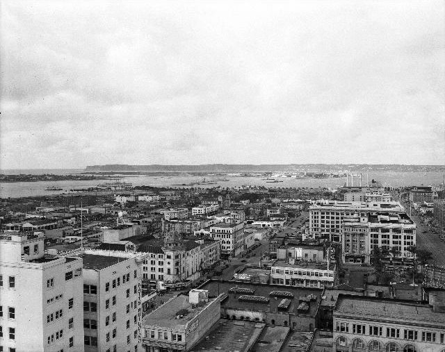
It’s not an easily adaptable building because it’s a fortified mall. And I recommend we be as ruthless with it today as they were to what was there before it (historic picture below), which was adaptable urban streets and blocks. It’s a 1980, stand-alone, single-use district within downtown. Next would be to retrofit the 1950/60s building along B Street with a completely different set of tools to transform just offices to offices/hotels/housing. And then transform seaport village, those low-rise, suburban townhomes around Pantoja Park.

The city is never built-out… especially when its full of single-use buildings and districts.

Slide 1 - Horton Plaza
Slide 2 - The streets closed to make Horton Plaza
Slide 3 - Rational (purple) and Irrational (beige) buildings
Slide 5 - How to Fix it with new rational buildings (deep purple)
Slide 6 - Contemporary Retrofit of Suburban Shopping Center

How to fix…

Existing Context

A City Hall Worthy of San Diego

Public Space, San Diego, Urban Design

Let’s Rethink City Hall… and put it back on our waterfront! Let’s show our civic pride in reconnecting the city to our great bay! And all of these IQHQ buildings are empty anyway. We can trade Papa Doug Manchester 101 Ash for the Broadway & Harbor block, and build a great and beloved grand City Hall. City can lease the existing buildings for administration/staff offices and everyone, from citizens to staffers, will feel good about going to the bayfront to govern our great city.

San Diego has a history of moving (after burning it down down) city hall, starting in Old Town (burned), then to Market & 5th, Waterfront, and C Street (should be burned), which has never been a beloved place anyway. It too was just a development scheme by C. Arnholt Smith… let’s make it work for us this time.

Our important civic buildings should be located on our best sites, and Broadway & Harbor is that. Use the C Street land sale $$ to build a new Chamber/Hall on our best site. And let’s be proud of how we govern our great city on the bay.

How I Got Here…

Leon Krier, San Diego, Urban Design

First, one of the many reasons I owe Mr. Michael J. Stepner, FAIA, FAICP, more than I can ever repay him is because he helped me find my professional path. My career as a planner started in Honolulu and then San Diego. I remember reading in the newspaper about Mr. Stepner being fired by a crude City Manager, Jack McGory, and then hired back by the city council, who overruled Jack, because he was rightfully leading San Diego towards its mixed-use, walkable, transit-supported future. Mike’s story resonated with me and that he had great credibility.

Second, here’s my new urbanist origin story. I was working for an architecture firm in Daegu, South Korea, during the Asian Tiger economic boom from ’93 – 97. And I found myself designing their first retirement communities using my suburban SoCal drive-thru lifestyle design tools. Traditionally, Korean elderly give their inheritance to their children when they moved in with their children’s family and they lived together in their compound housing (totally different from modern Western civilization tradition). And I designed their first car-oriented ‘silver towns’ because the middle class and car ownership was rising and they had money to put their elderly in homes. I met with the owners and looked into the sad eyes of one of the elderly men in the room who was envisioning his life isolated in a retirement box, alone.

I realized I was destroying a culture and that I had power as a designer and with great power comes great responsibility (credit: Stan Lee). So I knew I needed a deeper understanding of my craft and further my education. So I starting searching…

Around that same time, 1997, I took a job in Singapore to master plan port facilities with housing for imported labor… and none of those cheaper laborers imported had a car. These were exclusively walkable neighborhoods for 1,000s of workers. If the port facility was in Malaysia, they brought in Indian workers, if in the India, the brought in Philippine workers, and so on. Going into the interview, I remembered reading about Mike Stepner designing walkable, transit-station areas in San Diego and hiring Peter Calthorpe. So I bought Peter’s book, The Next American Metropolis, read it on the 30+ hour flight, copied his drawings into my notebook that I showed at the interview and got the job.

In Singapore, I found an older Calthorpe and Sim Van der Ryn book (’91), Sustainable Communities, and on the last two pages, they reference Leon Krier as the future guru of planning sustainable communities. Of course Leon is the godfather of the Congress for the New Urbanism because he taught at Yale when Peter, Andres Duany, Liz Plater-Zyberk, Stefanos Polyzoides, and Andrew Malick’s father were students there. And down I went, into the Leon Krier rabbit hole. Amazingly, within my own profession, I found the innately humane power in building walkable places that people loved. And it energized my career.

Unfortunately, in ’98 my father passed away but it left me enough money to go get my Masters in London (Univ. of Westminster, ’00) and put money down on a house in San Diego (’01). I went to London specifically to learn from Leon as I interned with the Prince’s Foundation, but I didn’t get to meet Leon…

Returning to San Diego, I worked on the County of SD General Plan Update and I’m asked by an NU colleague to go on a charrette in Chico, CA (’04), led by Leon Krier! My boss said I couldn’t take the time off to go so I quit the County and went (they hired me back as they didn’t expect me to quit). I purposely watched Leon and immediately sat at the same table as him, along with Geoff Dyer, who’d become my business partner and dearest friend. We sat there, stole scraps of drawings, listened, learned, copied, and soaked in the charrette that was a beautiful mess. Leon knew my London teachers and Princes Foundation colleagues and we became friends.

From there, Leon and I spent time together at New Urbanism’s annual Congresses. And when his book, The Architecture of Community, came out, he came to San Diego to lecture in Balboa Park, and we packed the Photograph Museum theater to the rafters, which was real meaningful to Leon at that time. He came back again a couple other times and together we drove my convertible Porsche across the desert for him to lecture at Univ. of Arizona. A memorable moment at one of his lectures in the NewSchool of Architecture, he asked the audience if anyone in the room had ever designed a tower… and in the front row, only Frank Wolden raised his hand!

We were able to spent a lot of time together then and during Covid, when he was trapped in his Cayala, Guatemala, studio for several months, we recorded these vlogs (and here) to talk about design, history, philosophy, and beyond.

And while in San Diego, he’s come up some of his more recent ideas that he’s published and we continue email debates on topics/issues, such as Corbu/Speer and vertical transects. His design idea for Coronado’s toll booth landing area is brilliant, using different height columns in a circle appear to ‘move’ when driving across the curve of the Coronado Bridge. 3-dimensional thinking. Here and here are a couple of links on his visits to San Diego.

My Taco Shop Theory…

Economics, San Diego, Urban Design, Urban Planning, walkability

I write, draw, and lament often about how great mixed-use, walkable, transit-supported urbanism is for our civilization. In my part of world, San Diego, one our most civilizing characteristics is the local taco shop(s). Taco shops are ours and we do them best, especially in comparison to LA, ‘Frisco, and Sacramento. And I have a theory… “the best taco shop is the second closest taco shop to your home.”

Another theory I subscribe to is the use of the ‘transect’ to design, plan, and build neighborhoods. The transect is an environmental research tool. It is a cut or path through part of the environment showing a range of different habitats. Biologists and ecologists use transects to study the many symbiotic elements that contribute to habitats where certain plants and animals thrive. The urban-to-nature transect outlines our human habitat in a similar fashion. See here: https://transect.org/index.html

natural transect
transect

And the Transect Zones (T-zone) range from the most urban, T6, to the most natural, T1. And there are 4 other place types in between. The Transect can be used at the regional scale. For example downtowns are a region’s most urban, thus T-6, and State/Federal parks, T1, are the most natural areas that need to be preserved. Agricultural reserve areas (T2), edge of town suburbia (T3), small town centers (T4), and the middle of towns/cities neighborhoods are mixed-use (T5). And the Transect is best applied at the neighborhood scale.

Each walkable neighborhood, approximately 120-acres, .25 mile distance from center to edge (approximately 1,250 linear feet), and these have at least 3 transect zones within it to provide a mix of uses, places, spaces, and people at different income/life levels. The neighborhood main street center is T5, the neighborhood general area with a few corner stores is T4, and the neighborhood edge is usually T3 that leads to natural corridor or the next neighborhood edge leading to another neighborhood and its main street center.

This my complete, walkable, mixed-use, transit-supported neighborhood with the 5-minute walk from the neighborhood center to edge outlined:

And here are where my local taco shop and trucks are located by Transect-Zone:

And here is the location of my next and favorite taco shop:

If I took the time, you’d see that my favorite taco shop is on the edge of the next neighborhood to my south. It’s center is located a neighborhood grocery store (Food Bowl, who make great tacos in their deli too). And our older streetcar neighborhoods in San Diego are expertly shaped with neighborhood centers located every 5 to 10-minute walks apart from each other and our #2 Bus stops. And, every neighborhood essentially has a great taco shop located in it. To the north, The Taco Shop is located another half-mile to the north, then another favorite taco shop, open 24-hours, Saguaro’s, is another half-mile from there.

Below is a transect map of the neighborhood’s in the North Park Community Planning Area. My neighborhood is to the furthest south (and half in Greater Golden Hill). The Taco shop is on the edge of the next north neighborhood (see the off-set Upas St intersection). And Saguaro’s is on the edge of the next neighborhood to the north, and so on. Notice they’re all located on 30th Street, the only north/south street connected South Park/Golden Hill to North Park and all of the tacos shops are located on it (and Fern St where it changes names).

One of San Diego’s best cultural elements are our taco shops. When I travel somewhere for more than a few days and return… my first meal home is usually from a taco shop because I need it. And we’re fortunate enough to have a taco shop in most of our urban neighborhoods. I’m thankful for my local, but I eat there too often and it’s staled to my tastes… and it’s too close. A 5-minute walk to/from my house to my local taco shop only burns a few calories compared to the amount of calories served up by my favorite burritos, rolled tacos, and flying saucers.

Theories…

San Diego, Urban Planning

I believe your favorite taco shop is the one that’s the 2nd closest to you. Because you eat at your local taco shop too often, so it gets dull… while being thankful its there. But that 2nd closest shop?!? Yeah, that’s the one that has the stuff that have to make an effort to get there and it’s just that much better than your local shop.

I believe this to be true.

I believe San Diego doesn’t have a parking problem, it has a walking more than 50-feet problem. In fairness, I’ve seen Marcela Escobar-Eck, a San Diego consultant, tweet this before too. But, I see people driving in circles to find that as-close-as-possible space, complain about parking, and not just drive to the edge of the parking lot or a block over and walk to where you want to be. It’s silly and selfish… but we’re from silly and selfish stock.

I know this to be true.

I believe what Mike Davis was absolutely brilliant and wrote the best pieces on social equity and inclusion/exclusion than anyone in our business. He was as kind and giving as he was brilliant. A giant, lost.

And I think this is true.

Family is the basis/core of civilization. Our sense of belonging or home or family (groups) equates to providing us a moral responsibility to take care of each other and our home(s). This does not apply as innately to global-scale industries, economies, businesses, politics, and environmentalism. That’s a reason for the disconnect between mitigating for global warming, building a traditional neighborhood, and living in a suburban cookie-cutter house.

San Diego/Tijuana is a World Design Capital

San Diego, Urban Design

This is an excellent article about the need for design innovation in SoCal, and very apropos to San Diego. In short, the author explores ideas about the need to ween ourselves off of our car culture and recommends Building Expositions: Design thinking is applied to urban design through rapid urban prototyping, and as such through the primary tried and proven vehicle of international building exhibitions, which have had a successful track record for more than a century.

San Diego/Tijuana has a history of important building innovations, starting with San Diego’s two early 20th century world expositions. First with the invention of Spanish Revival in 1915 by Bertrand Goodhue, and then with suburban sprawl in 1935 by the Federal Housing Authority. The suburban auto-oriented pattern of building was first exhibited in ’35’s FHA suburban model homes by Neurta and Eckbo, and it changed the world.

In the 1950s, San Diego also invented Climate Change (Scripps GhG/carbon measurements by Roger Revelle and Charles Keeling), which dramatically changed our world too. We invented the modern LRT system, Transit-Oriented Development (Peter Calthorpe/Mike Stepner), modern ranchette house (Cliff May), modernist tilt-up construction (Irving Gill), Salk Institute (Lou Kahn), downtown urban malls (Jon Jerde/Frank Wolden), and we have UCSD’s Teddy Cruz’s study on cross-border construction techniques found nowhere else. Our latest UCSD/Tijuana Migrant Shelter (Teddy Cruz/Fonna Forman) and Cross-Border Terminal (Ricardo Legorreta/Blackson – yeah, I did the Site Plan) are important innovations too. Our bordering cities have a successful history of building innovation that needs to be celebrated.

This is the value of next year’s WDC2024. The World Design Capital is a legacy thread that builds upon our history of innovation and has the potential to reshape our future.

Buildings are spaces and places we inhabit as humans. Virtual Realities, Artificial Intelligence, and Autonomous Vehicles are appropriately named… they’re fake, false, impersonal, and limited. Salk/UCSD’s CAVE has faded after so much bluster in 2007, but is an early 3D/VR innovation, and something to be proud of. We need to build them to test our 21st century spaces and places, and share the risk/financing/rewards. For example, a heavy timber building was quietly built and successfully earthquake tested recently at UCSD. We need to test/build modular as well as Doug Austin’s concrete prefab patent idea. We need a place to share this knowledge and get onto our less suburban, auto-oriented future our climate and society demand.

UCSD is leading our region in design thinking, and its Park/Market facility is our region’s design creativity Hub. It’s the center of our WDC2024. We’re fortunate to have both coincide today.

When debating NIMBYs, I like to say that a community’s “character” is found in its memory (history) and expectation (vision). This idea of an International (USA/MEX) Building Expo center is a great idea and we have a history of success with it. Now we are able to ideate a new vision for our region during WDC2024 and beyond. It’s a character defining moment!

And I wish to carry this idea through the WDC year as one of its on-going legacy goals. #LFGSD!

Pop-Up Pandemic Plazas and Parklets

Innovation Districts, Public Space, San Diego, Urban Design, Urban Planning

PopUp1

Three Types of Open Air Spaces

PopUp2

Pop Up Parklet

PopUp3

Pop Up Plaza

PopUp4

Pop Up San Diego Scenario

PopUp5

Pop Up Spaces Defined

PopUp6

Pop Up Plaza, Parklet and Full Block Plaza

These illustrations and site plans are intended to assist our cities in enabling open-air markets in streets and rights-of-way. A follow up to the Podcast interview I had with Andrew Keatts this week (click here), the math shows that a full block provides the most area to enable more dining and shopping to be located in neighborhood centers located every half-mile or so apart. These ‘streateries’ would be managed and operated by local Business Improvement Districts (BIDs) and Main Street organizations in order to be equitable across the city without it being shop by shop and coordinate efforts and resources (money) to enable us to have a safe place to go to dine in/out, shop in/out, and communicate with others.

San Diego simply doesn’t have enough local parks and plazas to handle the excess space needed to bring small businesses back to our neighborhoods. These places are intended to help small businesses reopen, as well as provide more public space to safely re-emerge from our homes and back into our neighborhoods. These standards would mitigate for social distancing while allowing the local shops to expand their capacity with the biggest issues to be planned for are conflicts between cars and people and maintaining socializing distancing.

The state is beginning to allow shops and restaurants to reopen at 50% capacity and still offer take out service. These plazas are intended to provide that other 50% capacity to help these businesses. In these standard 3-feet by 5-feet ‘safe zones,’ surrounded by a 6-feet social distancing area, are able to comfortably provide a table with two chairs, or a merchandise display, clothing racks, and a place to sit and wait for food while enjoying beverages in the summer time. They’re a safe relief value from the past 3 months of quarantine.

Importantly, American Disabilities Act standards are maintained. Stormwater runoff at the curb is maintained. And, a 15-foot clear fire access lane is maintained through the center of the streetscape as these spaces are marked off by tape and paint. The traffic barriers and reflective tape/paint costs money by the BIDs and local municipalities. The maintenance, cleaning, and daily operation will be a public-private partnership with local shops being active participants in managing these new public spaces. The shops that front onto the space, as well as in the immediate surrounding area, are able to benefit from this extra area and enhance the experience with lighting, signage, shade, seating, and sounds.

The National Association of City Transportation Officials (@NACTO) has recently shared its open Streets for Pandemic Recovery design guidelines here. And, a favorite colleague,  Mike Lydon of @Streetplans, is leading a national Open Streets effort, which can be heard/seen here.

We rarely go out shopping and dining to stimulate the economy. The quality of these dining or shopping experiences will entice us to spend time and money because we go places for the experience. Opening streets to businesses involves a plan and design outcome that makes being there worth the time spent. I hope these are useful in starting that plan and beginning the design of our brave new world… outdoors!

Conservation of Culture Conversation

Public Space, San Diego, Urban Design

In the past, our culture (music, socializing, celebrations, food, worshipping) had secure foundations in public buildings, streets, squares and plazas (church, concert hall, theater, pub, halls, and markets), and in the private home.

Our parents added television, cars, the highway, and suburbia to these public and private places (drive-in theaters, drive-thru diners, freeway overpass protests, tv movies, tv evangelist, tv news, home theaters, homes cafes, home entertainment, backyard pools), shifting our culture towards a more private life.

Today, we are adding smart phone technology to these public and private spaces while shifting away from insular private suburban culture and towards a more balanced public and private life. These smart phones are our 21st century version of urban renewal, allowing us to re-inhabit and re-animate public buildings, streets, squares, and plazas cheaper, faster, and with more friends and family.

Within a century, everything has changed with how we share music, socialize, celebrate, eat, worship, and share our selfies with smartphone technology in our daily lives/culture. And, with this pandemic… it’s dramatically changing again. See you on the other side!

In reference to Roger Scruton’s article, https://www.futuresymphony.org/why-musicians-need-philosophy/