Its not Smart Growth… It’s Called Avoiding a Housing Crisis

Climate Action Plan, San Diego, Urban Design, Urban Planning

(First printed in here on March 1, 2016)

California’s Bay Area housing disaster tells Southern Californians that our housing crisis will only get worse and doing nothing is both an irrational and irresponsible response. We are faced with deciding to have more neighbors or pay more taxes as we desperately need money to fix our city’s crumbling infrastructure. The conundrum is that we despise taxes and the mere mention of ‘density’ polarizes any discussion into either demands for no new growth or building tall towers.

I believe answers to meet San Diego’s housing demand are found in the following two-tier approach:

The first tier is a baseline ‘Beach Density,’ which I’ve written about here. An existing housing model found in our older, traditional beach neighborhoods that fills our need for the ‘missing middle’ types of housing. This model is essentially a residence or shop with three (3) to five (5) units on each lot that are no more than two (2) to three (3) stories tall. All of these homes and businesses are mixed together every few blocks or so. By allowing every lot in San Diego’s urbanized areas to have up to five (5) units’ by-right, we have the opportunity to solve for our critical housing and infrastructure financing deficiencies without dramatically altering our city’s character. Ultimately, the entire city can enjoy and benefit from our healthy, outdoor lifestyle that this Beach Model provides us.

The second tier is more precisely located ‘Climate Action Zones.’ Per its recently adopted Climate Action Plan, the city of San Diego is required to take actions to “Implement transit-oriented development within Transit Priority Areas,” and to “[a]chieve better walkability and transit-supportive densities by locating a majority of all new residential development within Transit Priority Areas.” In combination with the Beach Density’s baseline housing bump, these Climate Action Zones are intended to achieve our city’s legally binding Climate Action Plan within a reasonable timeline.1 We cannot expect the city to complete it all at once, but it can accommodate for an urban acupunctural approach… pin pricks at key points to make great change.

These ‘zones’ will require updated and new city policies, including community plan updates, to facilitate increases of land use intensity near our region’s transit investments. Fortunately, we have one of our nation’s first and best Transit-Oriented Development (TOD) guidelines written by planning guru Peter Calthrope in 1992 that have sat neatly on a shelf in the city’s Planning Department over these many years, having been emasculated by our currently suburban and convoluted parking regulations. We should dust these off, as they’ve been proven throughout the world – as well as Portland – to increase transit ridership. In addition, we should manage our off-street parking and simplify one space per unit to permit transit, walking, and biking to be as advantageous as driving.

SD GP Map Before

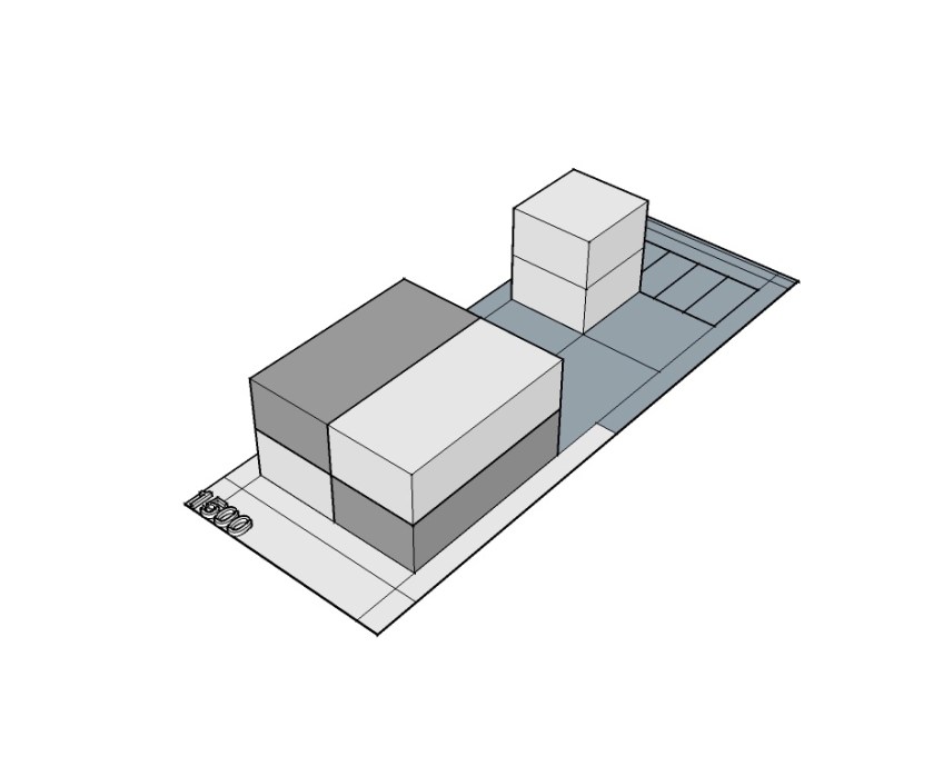
City of San Diego Plan Before Climate Action Zones

A ‘tower’ in San Diego is a building over 7 stories, and are only appropriate in one or two areas beyond downtown. However, 4 – 6 stories have been built in our old streetcar neighborhoods since their founding 100 years ago, as this height is a ‘walk up’ and appropriate in ‘walkable’ neighborhoods. Climate Action Zones should be located on the 4 to 8 blocks (600 feet radius) around primary intersections with cross-street transit service, currently built as 60’s era gas stations, drive-thrus, and strip centers.

SD GP Map AFTER

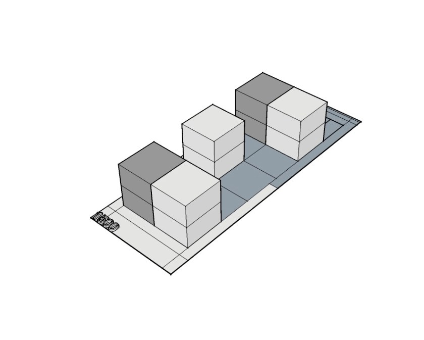
San Diego Development Potential with Climate Action Zones

Data shows that the majority of trips within 600 feet of a transit station are made by transit, bike or foot. These zones would permit mixed-use, up to 7 stories/90 feet tall max, using our TOD guidelines that allow for shared parking ratios with limited Community Plan conformance reviews in order to ensure transition steps to protect neighbors. Rather than waiting to build another Rancho del Rancho on our suburban periphery, these retrofitted intersections will be the focus of new development for the next 15-years. Successful case studies include Salt Lake’s Commuter, Light Rail (LRT), and Streetcar corridor economic engine, Dallas’s new LRT stations and Klyde Warren Park and Historic Streetcar value explosion, and Denver’s new infill coding success.

It is untenable to keep century old urban communities from change. But we know change brings fear to local citizens, which is why this two-tier approach makes very clear that new housing can fit comfortably within our current lifestyle if we explicitly plan for what we need using San Diego proven models. Finally, we have to plan for the change we want in order to fix our infrastructure, add public spaces, and to continue to be relevant to working economies by providing attainable housing, accessible transportation, and our unique outdoor lifestyle.

Beach Density

San Diego, Urban Design, Urban Planning

San Diego’s Missing Middle

The Bay Area’s housing disaster tells San Diegans that our housing crisis will only get worse and doing nothing is not an option. We have to decide whether we want more neighbors or to pay more taxes as we desperately need money to fix our city’s crumbling infrastructure.  The conundrum is that we despise taxes and the mere mention of ‘density’ polarizes any discussion into either demands for no new growth or building tall towers. Fortunately, we have a housing model that fills the ‘missing middle’ that more responsibly grows our city.

San Diego’s beach areas are home to our most vehemently defended neighborhoods. It’s healthy, outdoor-oriented lifestyle, when coupled with parking constraints, begs people to walk and ride bikes year ‘round. Our beach density model is essentially a residence or shop with three (3) to five (5) units on each lot that are no more than two (2) to three (3) stories tall. All of these homes and businesses are mixed together every few blocks or so. While housing prices are very high in the beach areas, this is mostly due to its finite land availability and layers of regulatory constraints, but those are lessons to be learned. Our beach density’s real value to the rest of San Diego is found in its mixed-use walkable urbanism pattern/model that creates more housing and economic development opportunities.

SouthMission

South Mission Beach’s Gentle Density (Image Creative Commons)

The best places to test this middle ground housing model would be any neighborhood in and around our existing Urbanized Areas. Such as, Southeast San Diego, Golden Hill, South Park and along our major corridors, such as El Cajon Boulevard, University Avenue, and Bay Park, City Heights, and the cities of La Mesa, Lemon Grove, and National City.  Hurtles to allowing for this gentle uptick in housing would primarily be our citizen’s natural ‘fear-of-change’ reflex, which is why using a local model makes sense (as opposed to an imported Portland or Vancouver model). This is somewhat due to our quality of life being ‘precariously’ high, as our home values are a major part of our personal wealth. Therefore, we are very leery of any change that may affect any of that value. 

Another issue will be found in unbundling the many layers of inconsistent development rules and regulations. Today’s zoning rules are based on a 1960’s suburbia building model while Pacific, Mission, and Ocean Beach areas were built in the pre-zoning traditional neighborhood era. In addition, outdated traffic calculations are still in use to measure and mitigate for new housing wrongfully giving us suburban infrastructure facilities and financing estimates. Finally, we would need SANDAG to allocate meaningful funding of pedestrian and bicycle facilities to improve our sidewalks, street trees, lighting, bike lanes, cycle tracks, and transit stops.

The benefits of urbanizing ‘elegantly’ are more urban housing choices with healthier lifestyles that lead to less demand for new suburban housing in the back country, and a spreading-of-the-wealth as local land owners will build most of these units, as opposed to international developers, ensuring that rents are recirculated within our economy. With average lot sizes in traditional San Diego neighborhoods ranging from 5,000 to 6,800 square feet, five (5) units on these lots on a typical lot would support regional transit service, neighborhood scale shops, restaurants, and professional office. And, assurances in maintaining the beloved character of mixed-use walkable places will be found in making any deviations from more precise zoning rules impossible.

Our city is in desperate need for ‘attainable’ housing and our beach density model provides the most fitting solution. By allowing every lot in San Diego’s urbanized areas to have up to five (5) units’ by-right, we have the opportunity to solve for our critical housing and infrastructure financing deficiencies without dramatically altering our city’s character. Ultimately, we can all enjoy and benefit from our healthy, outdoor lifestyle the beach model provides us.

4 Square - 3

2.1.2 - 5

2.2.1 - 3

Wide Variety of Design in a Narrow Range to Respect Neighbors Privacy (Images by David Saborio)

UPDATE (12.28.2015): How to Allow for Beach Densities:

  • Eliminate off-street parking minimums (Transit/Bike/Walk);
  • Eliminate minimum lots sizes and minimum lot dimensions;
  • Up-zone any parcel that allows a single family house to 2-5 units;
  • Covert per unit development impact fees to per SF impact fees and eliminate development impact fees in the places where you want development;
  • Take Main Street back from the State DOT. (increased revenues from getting on-street parking back and taming the overly wide arterial will more than cover the increased maintenance costs);
  • Amend your adopted fire code (zero lot line for sideyard setbacks);
  • Adopt City of San Diego endorsed NACTO Street standards;
  • Allow for self-certification by Licensed Architects. Building permit issued by the Architect with required notification of the municipality to keep the assessor’s records current.

On the Perception of Safety, Density, and Other Voice of San Diego Articles… Plus a New Urban Film Fest!

Urban Design

Last week I wrote this article on Urban Design and our sense of safety and place that was well read.

And, a few months ago I wrote this article on density that is in this blog somewhere else, but I wanted to let Voice of San Diego know that I appreciated their willingness to let me share my professional perspective on how to make San Diego a great city.

And, this week is the New Urban Film Festival at the ACME Theater in Hollywood. Tomorrow is our CNU-California Chapter Annual Meeting and Award presentations. Last year, City of Santa Monica City Manager Rick Cole won our annual Paul Crawford Award. This year, we awarded it to Sustainable Transportation Guru, Jeffrey Tumlin, and honored the work of the Local Governments Commission. Hope some of you can join us tomorrow for the presentation. Cheers!

Photo: Mario Covic

Stop Talking about Density and Start Talking about Place.

Urban Planning

When I say, “density,” I picture a place like Little Italy. It’s a mix of townhouses, walk-up flats, small shops, churches, markets and restaurants. I can walk and bike around or drive my car when I want. I envision bumping into friends, enjoying our new Waterfront Park, drinking craft beer and eating from a variety of restaurants with a smile on my face. 

But, when I say “density” to my mom, who lives in the a country ranch house and rides horses, she pictures downtown towers filled with people, an outright oppression of her outdoor lifestyle. And to my granny, “density” means the Huffman six-packs looming over her North Park neighborhood bungalow. These are the hastily built six-or-so apartment unit complexes on single-family lots throughout San Diego’s Mid-City. Granny’s still bitter.

You can measure the density of all of those things, because that’s all density is: a measurement of how many homes fit within an acre of land. That’s all. An that’s all it should be.

My mom’s ranchettes could be between one home per 20 acres or four homes per acre. My granny’s bungalow is between eight and 14 homes per acre, depending on whether she builds a secondary apartment or “granny flat” in her backyard. The townhouses and condos in Little Italy are between 20 and 60 acres per acre, and downtown’s towers are 80 or more homes per acre. 

That’s how we use “density” to measure different types of homes.

But “density” cannot do more than that. It doesn’t tell us what we need to know to make decisions about the places we want to live, and it misinforms the development discussions we have about our future. We see this in our city needing all of sorts of other restrictions, aside from density, to create different places, such as suburban Sabre Springs, more urban North Park, Little Italy or downtown. We have to add in restrictions for height, setbacks, parking ratios and how the property can be used. These many other requirements are what makes a zoning ordinance an unwiedly tome, perfect for bedtime reading.

San Diego is now open for business and dreams of being a corporate business hub, but housing for middle management is hard to find an build. And, focusing on density alone skews the market for building homes we know we need and the market will build.

Community groups will demand the city’s planning department to keep densities artificially low in the hopes that it will keep new housing away. These lower densities intended to stop growth actually push developers towards building just enough very expensive homes to make their profits. These larger, more expensive units aren’t appropriate for our older streetcar neighborhoods. This creates an unintended consequence: introduction of a different building type that conflicts with a community’s character, or skips a step in transitioning from less urban to more urban.

And, high density itself does not make for better development. Density doesn’t tell us anything about context, such as being in located in the center of a neighborhood, or its edge. Neighborhood-scaled, modest, well-designed density is almost impossible to achieve because of all of those other restrictions mentioned above being out of sync with its context. 

Instead of addressing the issue head on – creating new codes and regulations that would allow the market to build a variety of housing types – we continue to rely on density measurements and conventional Land-Use Based zoning and hope for the best. So far that’s produced luxury towers, Huffman six-packs and large tracks of bland apartments in Kearny Mesa and Mira Mesa. The 50-year history of doing it this way has led to our collective mistrust in our neighborhoods between developers, locals, City Hall, and planning professionals. 

Density and land use zoning were borne of conflicts with the industrial revolution and propagated by old insurance companies’ discriminatory “redlining” practices against minorities in the 1930s. These companies outlined certain areas in red on maps and homes within these areas couldn’t buy insurance, which then became the neighborhoods where marginalized minorities were allowed to live. Having insurance allowed homes to become larger and more expensive, which came to mean lower densities in those neighborhoods. While these discriminatory policies have stopped, our current zoning and density maps reflect and continue old redlining practices to this day.

We need better tools to discuss how we build anything new in San Diego. 

I have long advocated for development regulations called “place-based codes” or “form-based codes” to replace the outdated zoning codes we use today. As seen in Denver, Austin, and Miami, they work better because they are built to help us understand that the type of places we want matters more than arbitrary measurements or ratios. 

We should allow the market to set how much retail, residential or office spaces there is on a given street. We should protect our valuable historic neighborhoods. We should control how buildings transition from new to old. We should understand how to transition between different types of buildings to maintain and cultivate a community’s character. It is clear that our long-held conventional approach isn’t achieving these goals, and we have new development tools that can do these things.

But focussing a conversation on “density” can’t. Remember, it is just a number.

(Thank you Andy Keatts for editing help. First published by Voice of San Diego here)