“Are we there yet?” No… But we’re close.

Economics

I shared this very good 2013 documentary with a potential client in Fresno, California. And he asked after watching it if I thought Fresno was better off today from the ideas and potential presented a decade ago? I know Fresno is better off today than it was 10+ years ago because of its public and private investments highlighted in the movie. And it was a real change to restart the building of urbanism in a decades long suburban culture.

Usually, this is when I self-righteously plow into the value of the New Urbanism and how 30 years ago we restarted and sustained this urban living revolution (with help from the sitcom, Friends). But it’s been 30 years, a full generation. And we should be fully building mixed-use, walkable, transit-supported urbanism at an industrial scale/speed by now, if measure by how long it took for the idea of suburbia to become reality. For example, Corbusier published the City of To-Morrow And Its Planning in 1929 and auto-oriented sprawl was in full bloom by 1959.

Calthorpe, Duany, and Katz all published their groundbreaking books on the New Urbanism in the early 1990s and here we are in 2023. Why aren’t we there yet? We’re most certainly moving in that direction, but too slowly.

That said, every city’s revitalization efforts suffered setbacks from the dramatic changes to how we work and commute due to the Covid shutdown. In California, we’re not building offices, retail is dead, and housing is king, because we’re building so little of it and we’re now working and shopping from home. I think that our Covid reset has to be overcome by all American cities, especially Fresno.

The overall development and construction industry in California appears to be in a static point between the pendulum swings of change, from suburban to urban building. And no major city in California is building enough housing to meet its market demands beyond the few thousand or so built a year on the fringes in master planned communities by the few big home building firms leftover from the 80s.

We have zero national or regional building/construction companies that build urban infill housing types at an industrial scale. We depend on 1,000 small-scale builders in every city to build enough housing to meet market demands, who are all learning and starting from scratch at the same time. Few are trained, prepared, or knows how to build urban infill housing at the scale of 2-3,000 homes annually.  Few city are able to build enough infill housing yet because:

– The Federal Government neither insures/subsidizes its loans/mortgages nor invests in our transit facilities.
– The State neither invests in transit services nor modifies building codes.
– The City neither invests in job training/education nor reforms its entitlement codes (they waive them).

All of these things were being done in the 1950/60’s as the Feds/State/Cities were in alignment to build suburban development at a massive scale. Feds changed its lending practices to subsidize single-family home mortgages. Fed and States built freeways and highways and their interchanges. States and cities built schools and colleges to educate ourselves. Cities created zoning to segregate work from home and enable master planned suburban development. America was a brave, new modern world post WW2. We were flush with cash and power and the world had changed dramatically by the mid-1940s.

Today, we’ve shoveled all of our post WW2 wealth over to the Saudi’s for cheap oil to fuel our autopian suburban landscape. And were breaking ourselves financially to maintain the out-of-date and cheap suburban infrastructure, which is a losing financial scheme. This is all explained much better by Chuck Marohn and Joe Minicozzi.

In short, we’re still not set up for building infill urbanism. And at this moment, California’s new urban infill development shift is being led by the State’s housing requirements and affordable housing incentives forcing city’s to waive their zoning (as opposed to reforming it). The Feds have started changing its policies too. But, these are just two of the six points the feds/state/cities need to be in alignment with in order to build infill housing at an industrial scale.

It’ll take time to get all three aligned, and we’ll get there as we’re well past the suburban experiment… which proved to be the greatest misallocation of resources in the history of civilization (stolen from James Howard Kunstler). Ultimately, when you tug on downtown Fresno you’ll find that it’s connected to the world (stolen from John Muir).
Town Planning, the Basics…

Economic Development

Town Planning involves processes undertaken by municipal planning departments to visualize, plan for, coordinate, and act on the three-dimensional physical layout of the town. This includes the zoning of different areas for various uses, such as residential, commercial, and office spaces. It also includes the subdivision of public property and the creation of public streets and park spaces. In addition, it takes into consideration the economic, transportation, political, legal, environmental, utility and sanitation infrastructures.

The goal of town planning is to achieve a desired urban form and to ensure that a certain level of accessibility, walkability, adaptability, efficiency, and economy are built in and adapted to over time. The public streets and spaces provide the long-term structure for building a town, and private development provides the day-to-day life within this framework is allowed to change and adapt as needed.

Today, town planning discussion have been dominated by zoning, the regulation of private property. However, this focus on zoning can sometimes overlook the more permanent and important patterns of subdivision, which involve the ordering of public and private property. Therefore, the challenge in town planning is to balance these two domains of zoning and subdivision to create a town that is healthy, safe, and welfare-promoting.

Basic Town Planning Elements Involves:
• Development Patterns – Suburban to Urban Street/Block Types
• Public and Private Spaces and Buildings – Location and Scale
• Planning Types – from the Region to the Lot
• Place Types – from Pristine Nature to the Town Center
• Character – From Memory to Expectations

(yeah, I used The Doug Allen Institute Chatbot to help me write this: https://app.docuchat.io/chat/48e19f7e-4aa5-4148-aed3-4be829e4c241)

Balancing the Math!

Economics, Social Justice, Urban Design

In general terms, the equation* to figuring out what the market rate housing rents are is to find the average local wage, times it employment opportunities, divided by the number of housing units available (*this is not a real math equation, it is assembling the elements that determine how the market place sets rents). While this equation is too simple, the basic point is that the rents rise in economically hot housing market cities because our growing upper-class wages are booming while the number of units available are limited. Higher wages times higher employment in cities that constrain new housing development equates to hot economic markets and higher rents.

Wages have somewhat stagnating for the shrinking middle class since the Great Recession. And those who are able to are willing pay more and compete for access to the ‘good life’ in a city that has great amenities, such as arts, parks, rivers (Austin and Denver), nice weather, beaches, bays (Miami and San Diego), and those cities with a lot of jobs and amenities (Bay Area, Seattle, and Los Angeles). This amenity factor still fits with the simple equation above as those cities offering jobs and amenities are too few and far between. And those few safe, amenity and job rich places are unwilling to build enough housing to meet market demand. As people continue to look for places to spend their valuable time to inhabit, wealthy cities will have those neighborhoods that remain expensive for a variety of reasons, while a similar neighborhood in the same city, only a few miles away, will remain stagnant or declining economically and socially.

Cities have a spectrum of economic value, from high to low, in context. Every city has a limited number of housing units available in high economically valued and amenity-filled neighborhoods to be rented by those few high wage workers who are in high demand and making significantly higher wages (+$200k/year). While the majority of a city’s middle class workers (+$60k/year) live in middle to lower economically stable and amenity-less neighborhoods. These new higher wages jobs drive up the rent in those few end-of-the-economic-spectrum high-demand neighborhoods and spill over into the edges of the middle class neighborhoods driving up rents and creating scarcity of middle-income housing (if more is not being built).

The most socially just urban design solution is to enable and build more housing and jobs with amenities in more neighborhoods rather than allowing for higher wage earns compete for those few amenity-filled neighborhoods scattered throughout most cities currently experiencing job growth. Importantly, these wages, number of units, employment opportunities and the need for more housing production issues are only relevant for stagnant cities and towns across the United States Rust Belt and Midwest states. Which moves us into social equity and justice issues with displacement in these high growth cities and neighborhoods. Local people who are displaced from their long-standing homes is the unjust effect of gentrification as values increases. While increased investment in an area has positive outcomes, gentrification associated with displacement of long-term residents deny citizens the ability to benefit from new investments in housing, healthy food access, or transit infrastructure.

To physically improve economically stagnant neighborhoods, with value generated from economic development and raise incomes, some manageable level of gentrification, minus displacement, is needed to improve and rebuild schools, parks, and market-rate development opportunities. Adding to this conversation is how work and shopping is physically changing in our neighborhoods, making 1960’s economic development models obsolete and new ways of building our neighborhoods and economies are making a huge difference in adding housing in older, pre-auto dominated neighborhoods. The auto-dominated suburban sprawl areas are in need of different tools to retrofit them. Conversely, in growing economic value markets, some manageable level of economic stagnation is necessary to enable more people to participate in the local jobs and amenities, such as subsidized housing, rent controls, and taxes.

San Francisco is an expensive because it is affluent with a growing population and no land made easily available for development. Enabling and building more housing would stabilize or reduce rents as it adds supply to the inherent demand. New amenities, new design housing design models, and new neighborhood patterns are emerging. And with enough new housing to reduce prices and mollify its globally hot market rates for housing, the quality of the city’s urban design will make a difference in how San Francisco attracts new wage earners and retains its aging and long-standing citizens.

Understanding this need to update its codes and design expectations, Seattle, Portland, and Denver have stabilized rents by building more housing. Using new zoning tools to allow for more housing in existing neighborhoods, these cities successfully changed their conventional zoning to a more form-based code type in anticipation of their 21st century development needs for mixed-use, walkable new urbanism. Form-Based Codes, or Objective Design Standards, prioritize where a building fits in its neighborhood context over the singular building’s primary land use. These cities reversed their once decimated social and physical fabric of their downtowns and historic neighborhoods by connecting and enabling isolated and segregated pods of development into well-connected and economically stable neighborhoods. And striking that balance between stagnant and hot economic markets.

Streets are Mixed Use too…

Economic Development

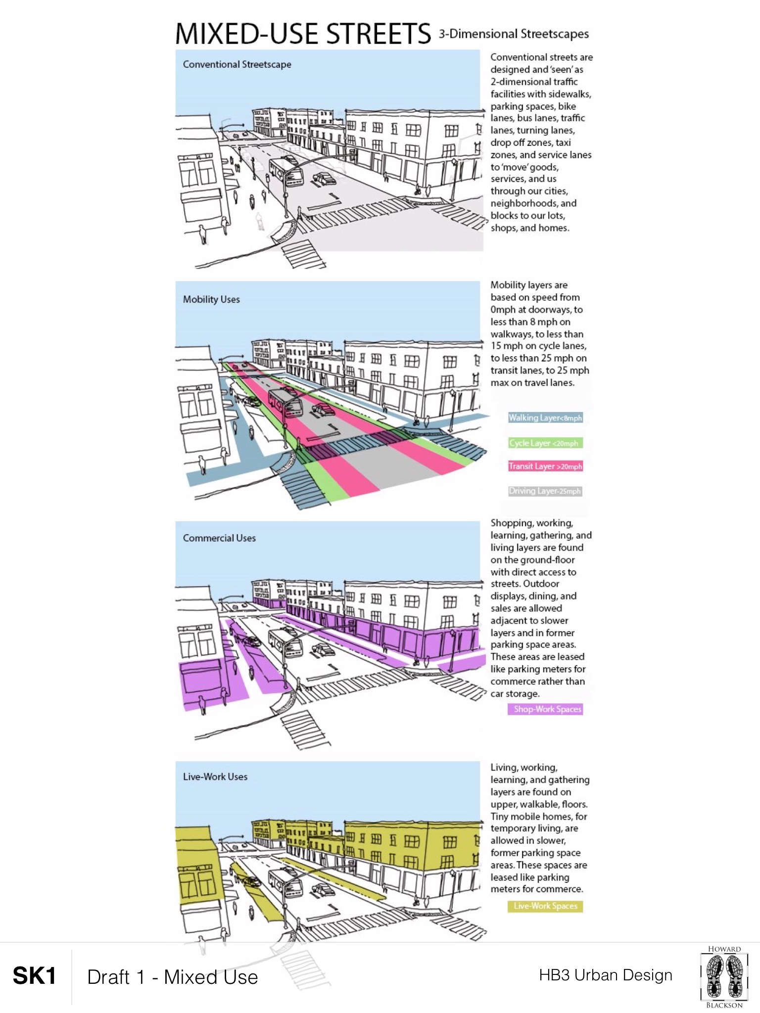
Streets have a mix of uses. Streets needs to be viewed in terms of a series of layered uses and speeds and be designed appropriately in relationship to the buildings that front onto the streets. The following are a list of uses per layer from building edge to centerline:

1) Ground floor Layer – The building fronting onto the street. Hold long-term Commercial, Residential, and Civic uses.

2) Encroachment Layer – Holds signs, less than public seating, dining, displays, deliveries, doorway zones. Holds more longer-term Commercial, Residential and Civic uses.

3) The Sidewalk Layer – <5 mph pedestrian travel lane with walkway, ADA access, on a clear path.

4) Furnishing Layer – Street Tree planters, more public seating, street lights, signage, parking meters, newspaper stands. Holds longer-term Commerce uses.

5) Parking Layer – Public parking stalls (angled/parallel/perpendicular/reverse angle), painted stripes, handicap stalls, transit stops, loading/commercial zones, drop off/delivery, and short/long-term car storage. Holds more shorter-term Commercial, Industrial, and Residence uses.

6) Cycle Layer – <10 mph zone between stopped parking cars and transit/travel lanes for various cycles ridden by various aged people.

7) Transit Layer – <25 mph zone between pulling in/out of Parking Layer and into the Driving travel through lane(s).

8) Driving Travel Layer – <25 mph zone (because any more than that kills most people)

All of these layers are mostly interchangeable and not every element is on every street. The big idea here is to introduce to the Furnishing and Parking Layers permanent Parklets, and movable/temporary Tiny Mobile Units in place of private car storage. These facilities can be rented and used for metered time periods as shops, hotel, and short-term residences. This is a shorter than permanent building Live-Work mix of uses that sit in the public right-of-way and reclaim the street from primarily auto flow use to a more livable and complex area that prioritizes the speed and scale of people. The image is an unfinished draft.

A forthcoming Mixed-Use Street PROPENSITY Map will illustrate where the more to less mix of uses on the streets are located. Think of it like a land use plan map for our streets. And, finally, for cities and places with overly scaled streetscapes, this is a way to reclaim public space for private commerce and housing (some public). A link to the ratio of public to private space discussion is here. What do you think?

Reforming Government to End Systematic Racism

Economic Development, Urban Planning

An answer to our demands to end systematic racism will be found in reforming our role and structure of governance. Rick Cole, former Santa Monica City Manager, made some solid points about how our government system of today is a turn of the 20th century Progressive Era construct, a response to industrialization, in an era of racism. Racism was prevalent throughout that political movement comprising mostly white, small-town, Progressive voters grabbed the reins of power from business elites, government anti-trust policies shifting power from the elite robber barons.

As Thomas Leonard writes in, Illiberal Reformers, Princeton University Press, 2016, “The industrial revolution and the rise of big business after 1870 dramatically increased American living standards, but the era was plagued by recurring financial crises, violent labor conflicts, and two deep economic contractions. In response, progressive economists sought to regulate the American economy through a new administrative state based on scientific management principles. They established economics as an academic discipline, while promoting and helping build regulatory and independent institutions such as the Federal Reserve (1913), the Federal Trade Commission (1914), and the International Trade Commission (1916).

Unfortunately, their policies were based on social Darwinism and eugenics and excluded groups deemed inferior — including women, Southern- and Eastern-European immigrants, Catholics, Jews, and blacks.”

Red Lining and resulting zoning were born from that era, which I have spent a career focusing on reforming. However, I only just now realized that this advocacy for zoning reform was a very limited view and that I should be advocating for government reform in the same way.

Here are Rick’s comments: https://planningreport.com/2020/04/19/rick-coles-resignation-santa-monica-city-manager-canary-coal-mine-cities….

My opinions on our Post-Covid future…

Economic Development, Public Space, Urban Design, Urban Planning

I got a blog, I’m an urban designer, and I got opinions… so let’s do this!

This epic pandemic moment will resonate in two scales. First, at the global scale:

  1. Easily identified our global economy as being very fragile and forgetting the trickling down part…
  2. Every nation now has the experience to work collectively to… limit Greenhouse Gas emissions. We can all stop driving and we will survive. When our Climate Change Pearl Harbor or asteroid moment occurs, we’ll have practice in how to collectively work on surviving it. This is the hope we were looking for.
  3. There are always people on the wrong side of history. The anti-vaccine groups, hate groups, and libertarians are not helping us collectively survive and thrive as citizens.
  4. Today’s cities exist because of jobs. With the local economies collapsing, big cities will continue to provide the most available jobs to any region, and will continue to grow as long-standing local economic jobs in small towns will be late to the economic recovery cycle. We must prepare for continued big city housing crisis.

Second, at the local scale:

  1. We are sheltering-in-our neighborhoods (place). We are seeing our local streets, right-of-ways, and parks as the health, welfare, and safety valves they actually are. Mindful of San Francisco’s parks post-1906 earthquake and fire, where people lived until they were able to rebuilt their homes.

Camp_1906_SFearthquake

2. Pre-Covid trends will be accelerated:

    1. End of Class A office park pods (retrofitted w/urban amenities);
    2. More outdoor dining/entertainment (pop up container parks)
    3. More online shopping & music concerts/events;
    4. More bike/walkable streets;
    5. More parks for our health, welfare, and safety (See point #1).

3. (Stolen from Bill Fulton) New Office Space as a place more specifically for meetings, sales, showroom, model building, virtual touring (gaming), lectures, parties, and fun and less as a dedicated production work space, allowing for more of that to happen at home. This more mixed-use flexible workspace will help retention of parents who are raising young children, and people who love working from home. It’s a retention program.

4. The neighborhood is the Rosetta stone of understanding how to build cities, which are very complex. And, at this moment, we are collectively learning more and more about our neighborhoods because we are driving less and walking more which is a good thing.

Plus, we’re learning how to respond to a global scale crisis, which is another good thing when the comet (climate change) hits.

More later.

Embrace the Scooter

Climate Action Plan, Economic Development, San Diego

The city’s public officials are obsessed with changing how we get around the city. But instead of just talking about expanding our mobility options, the scooter companies have come in and actually provided a change.

I have seen the future of downtown transportation, and it is fun!

The electric scooters from Bird and Lime are the greatest mode of travel in San Diego since my grandma rode through Balboa Park in a convertible or cruised Broadway in a hot rod.

The value of scootering is three-fold. First, getting around the city faster, easier and cheaper than in the old expensive convertible or gas-guzzling sports car is a big deal.

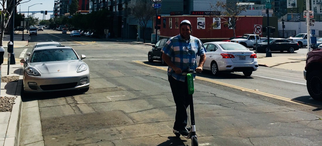
I work on the eastern edge of East Village, and my wife works on the western side of Broadway near the waterfront. If we want to meet for lunch, it’s a 25-minute walk, leaving little time to eat and walk back. Driving is faster, thanks to downtown’s one-way streets, which were designed for my grandmother’s hot-rod. But that still means a 10-minute drive for me, after which I pay up to $10 per hour for parking in a lot a few blocks away from my wife’s office, or peck around hoping to find street parking for $2 per hour. It’s a chore.

Instead, we can use our smartphones to find a scooter, walk one block to pick it up, and ride less than four minutes to drop it off at our destination. It costs $2 tops.

The city’s public officials are obsessed with changing how we get around the city. San Diego has adopted a Climate Action Plan that promises half of us who live near transit will get to work without a car by 2035. But instead of just talking about expanding our mobility options, the scooter companies have come in and actually provided a change.

I keep my helmet in my office. I ride on the street most of the time. But honestly, it’s not as safe to scooter on the street as it should be for three important reasons. The condition of the pavement is abysmal. Holes and cracks are treacherous no matter how you’re getting around.

Second, downtown’s long, straight, one-way streets facilitate high-speed traffic. Cars bunch up at each signal and roar to 35 miles per hour before stopping at the next light six blocks away. Once that first bunch of crowded, angry, honking cars pass by, scootering is a lovely experience on the street; our volume of traffic is usually low compared with the capacity our street network is built to handle.

And third, there is very little quality pedestrian, bicycle or scooter-oriented infrastructure built in downtown San Diego.

What these scooters are showing us is the fallacy that cars provide “independence.” Scooters will change how we get around downtown San Diego for many years to come.

There is a caveat: These scooters are not as appropriate for more urban cities like San Francisco, Chicago and New York. Those cities have tremendous transit service and wide, clear sidewalks, and are filled with lots of people, cars, trucks and commerce. San Diego’s downtown sits more comfortably in the Phoenix, Austin, Dallas, Houston and Denver scale of intensity and transit availability. We actually need these machines to bridge those gaps between Little Italy, Gaslamp, Ballpark and City College, as we continue to urbanize.

Give it time. Hopefully officials see the scooters as an opportunity to build the infrastructure needed to support such a fun way of getting around our extremely beautiful city.

[This was first published in Voice of San Diego on April 24th. I’d like to add that the ability to scooter around with your work clothes on it an advantage to using these versus bicycles for short, work-oriented trips. The fun, convenience, and cost combination makes scooters a viable mobility tool to cut emissions and auto trip to meet our Climate Action goals.]

An Ethical Approach to NIMBYism…

Economic Development