Designing Urban Places, My Process

Urban Design, Urban Planning

I begin a project by reading and listening to citizens, existing policy-documents, and experts in an area. Learning the issues and background information, or due diligence (now called data gathering), is the first step in generating ideas. My design biases are found in my appreciation for John Cleese’s creativity approach by being open minded with play to envision scenarios and closed minded to then focus on the design product afterwards. As well as my personal design process fitting within the spectrum of life… between life to death, night to day, light to dark, man to woman, formal to informal, yen to yang, etc… as an inherent basis for my design approach. And this third tool is to figure out where the place sits is more urban or more rural spectrum today and where it’s going in the next 5-10 years and then beyond.

Fourth, I begin designing (usually on an iPad/Morpholio Trace program) applying a variety of street, parks, and building types, from most intense to least intense, that explicitly guides new building towards a distinctive “character and sense” of place. See Leon Krier’s idea of how to coding for a specific community character here (note: there are only 16 character types). So using background info, my biases, and multiple street/park/building types tools… I then take an outside-of-the-box approach, looking at the surrounding context to identify public and private buildings and space patterns in the project area. These patterns are interdependent and shape the surrounding neighborhood characteristics. Identifying, understanding, and drawing inspiration from these patterns upfront allows me to address common issues raised in the first step.

Then I design within the project area with an inside-of-the-box approach, identifying these surrounding patterns within the design to coordinate the precise location of uses, buildings, spaces, services, and utilities with a focus on long-term social, environmental, and economic outcomes. Using these various patterns to identify a variety of buildings and spaces guides me to making design decisions that are either ‘in tune’ with its surroundings or it ‘stands out’ and accentuates a space or building. The design either blends in and fits harmonious with its surrounding patterns or its disrupts and breaks the patterns.

The combination of these approaches and techniques allow me to quickly make design decisions to create a specific character and sense of place, rather than leaving it up to chance… and the final design produces a new idea for a place that either respectfully fits within or distinguishably stands out from its local setting. With this start, I work again with local citizens, who have a unique understanding and knowledge of their communities, to gauge if their neighboring buildings, parks, and streets should stand out or fit in.

Local identity is a key in creating spaces that nurture community identity, instill pride, and positively energize communities. And I advocate for elevating the role of “good” design to a region’s public agencies, county, cities, advocacy groups, private organizations, and community groups, understanding that well-designed places are a practical and essential way to bring vitality and dignity to city living.

At the human scale, good design makes a difference in our lives by helping us feel safe and comfortable while walking and socializing in our neighborhoods, which helps us feel happier and experience a deeper sense of belonging to places and people.

And, at the city scale, good design makes a difference in enabling cities to attract and retain residents and businesses with inviting public streets, civic spaces, and interesting places more easily.

Ultimately, belonging to a place, and a home, is the idea that goes to the heart of what makes neighborhoods great. It roots our approach to urban design in respect. Respect for people and places, and a respect for tradition. It gives the fancy innovations and clever deconstructions a heart and a soul. An innovation is something new, something novel, maybe even revolutionary. But there’s another truth that’s deeply applicable to design, oftentimes the best innovations are ones in which a twist was put on something that has been done before.

What do you think?
My Taco Shop Theory…

Economics, San Diego, Urban Design, Urban Planning, walkability

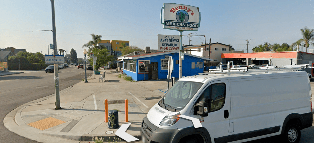
I write, draw, and lament often about how great mixed-use, walkable, transit-supported urbanism is for our civilization. In my part of world, San Diego, one our most civilizing characteristics is the local taco shop(s). Taco shops are ours and we do them best, especially in comparison to LA, ‘Frisco, and Sacramento. And I have a theory… “the best taco shop is the second closest taco shop to your home.”

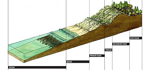
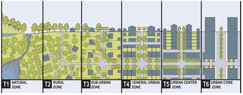
Another theory I subscribe to is the use of the ‘transect’ to design, plan, and build neighborhoods. The transect is an environmental research tool. It is a cut or path through part of the environment showing a range of different habitats. Biologists and ecologists use transects to study the many symbiotic elements that contribute to habitats where certain plants and animals thrive. The urban-to-nature transect outlines our human habitat in a similar fashion. See here: https://transect.org/index.html

natural transect
transect

And the Transect Zones (T-zone) range from the most urban, T6, to the most natural, T1. And there are 4 other place types in between. The Transect can be used at the regional scale. For example downtowns are a region’s most urban, thus T-6, and State/Federal parks, T1, are the most natural areas that need to be preserved. Agricultural reserve areas (T2), edge of town suburbia (T3), small town centers (T4), and the middle of towns/cities neighborhoods are mixed-use (T5). And the Transect is best applied at the neighborhood scale.

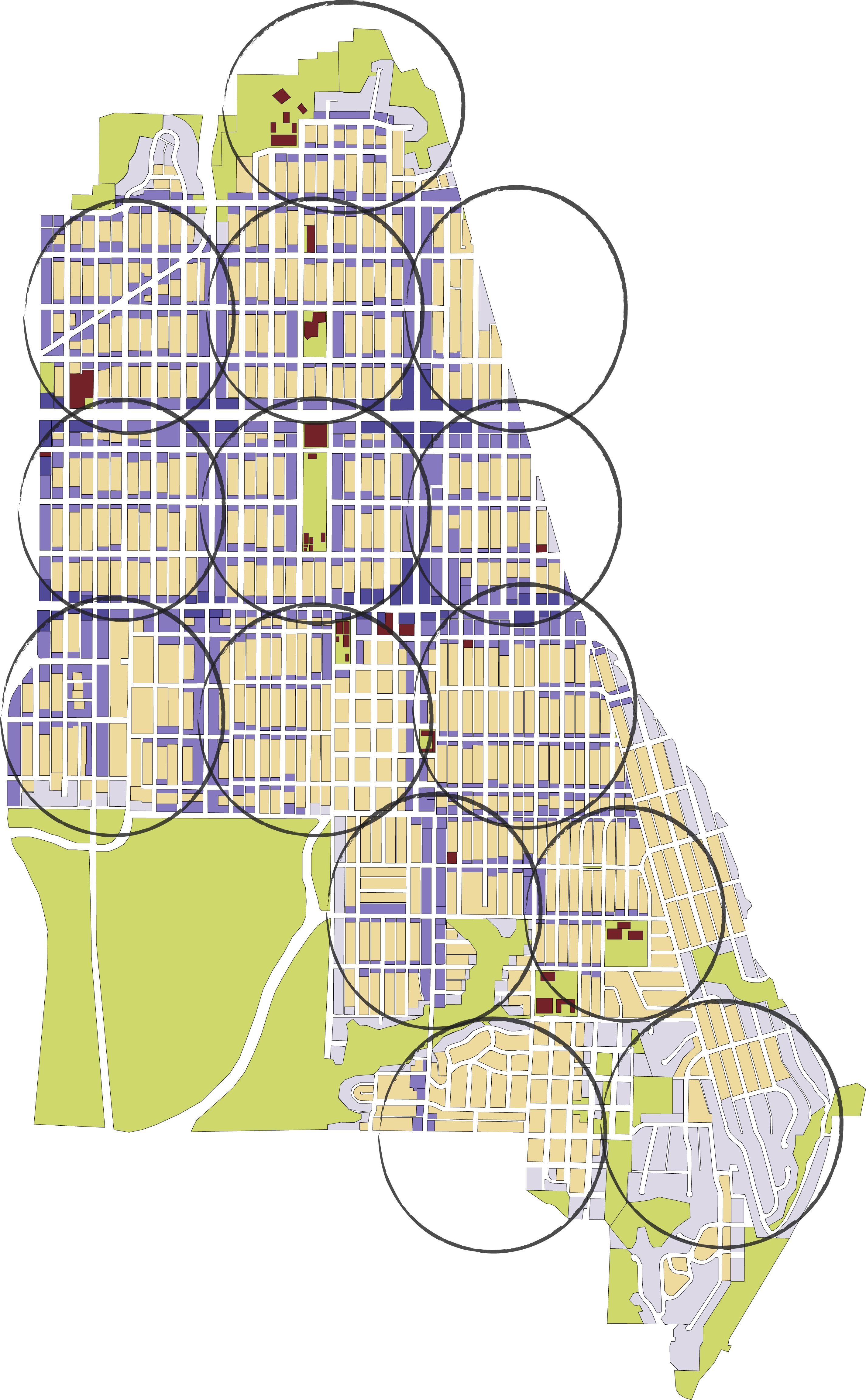
Each walkable neighborhood, approximately 120-acres, .25 mile distance from center to edge (approximately 1,250 linear feet), and these have at least 3 transect zones within it to provide a mix of uses, places, spaces, and people at different income/life levels. The neighborhood main street center is T5, the neighborhood general area with a few corner stores is T4, and the neighborhood edge is usually T3 that leads to natural corridor or the next neighborhood edge leading to another neighborhood and its main street center.

This my complete, walkable, mixed-use, transit-supported neighborhood with the 5-minute walk from the neighborhood center to edge outlined:

And here are where my local taco shop and trucks are located by Transect-Zone:

And here is the location of my next and favorite taco shop:

If I took the time, you’d see that my favorite taco shop is on the edge of the next neighborhood to my south. It’s center is located a neighborhood grocery store (Food Bowl, who make great tacos in their deli too). And our older streetcar neighborhoods in San Diego are expertly shaped with neighborhood centers located every 5 to 10-minute walks apart from each other and our #2 Bus stops. And, every neighborhood essentially has a great taco shop located in it. To the north, The Taco Shop is located another half-mile to the north, then another favorite taco shop, open 24-hours, Saguaro’s, is another half-mile from there.

Below is a transect map of the neighborhood’s in the North Park Community Planning Area. My neighborhood is to the furthest south (and half in Greater Golden Hill). The Taco shop is on the edge of the next north neighborhood (see the off-set Upas St intersection). And Saguaro’s is on the edge of the next neighborhood to the north, and so on. Notice they’re all located on 30th Street, the only north/south street connected South Park/Golden Hill to North Park and all of the tacos shops are located on it (and Fern St where it changes names).

One of San Diego’s best cultural elements are our taco shops. When I travel somewhere for more than a few days and return… my first meal home is usually from a taco shop because I need it. And we’re fortunate enough to have a taco shop in most of our urban neighborhoods. I’m thankful for my local, but I eat there too often and it’s staled to my tastes… and it’s too close. A 5-minute walk to/from my house to my local taco shop only burns a few calories compared to the amount of calories served up by my favorite burritos, rolled tacos, and flying saucers.

Theories…

San Diego, Urban Planning

I believe your favorite taco shop is the one that’s the 2nd closest to you. Because you eat at your local taco shop too often, so it gets dull… while being thankful its there. But that 2nd closest shop?!? Yeah, that’s the one that has the stuff that have to make an effort to get there and it’s just that much better than your local shop.

I believe this to be true.

I believe San Diego doesn’t have a parking problem, it has a walking more than 50-feet problem. In fairness, I’ve seen Marcela Escobar-Eck, a San Diego consultant, tweet this before too. But, I see people driving in circles to find that as-close-as-possible space, complain about parking, and not just drive to the edge of the parking lot or a block over and walk to where you want to be. It’s silly and selfish… but we’re from silly and selfish stock.

I know this to be true.

I believe what Mike Davis was absolutely brilliant and wrote the best pieces on social equity and inclusion/exclusion than anyone in our business. He was as kind and giving as he was brilliant. A giant, lost.

And I think this is true.

Family is the basis/core of civilization. Our sense of belonging or home or family (groups) equates to providing us a moral responsibility to take care of each other and our home(s). This does not apply as innately to global-scale industries, economies, businesses, politics, and environmentalism. That’s a reason for the disconnect between mitigating for global warming, building a traditional neighborhood, and living in a suburban cookie-cutter house.

Walkability Doesn’t End at the Front Door…

Urban Design, walkability

In the city making profession, we use the quarter-mile, or 5-minute walk, as a standard measurement of distance for planning neighborhoods and cities. It is a traditional baseline for a ‘comfortable’ walk before people will choose another mode of transportation1. A half-mile walk, or 10-minute walk, is another standard used to measure walking distance to comfortably access transit facilities.

These distances were first codified in the 1929 regional plan for New York and its 5-minute walking radius diagram by Clarence Perry (top image below). In San Diego 60-years later, Peter Calthorpe’s original Transit-Oriented Development to plan around our Light Rail Stations popularized the walking distance measurement in planning documents throughout the nation2 (bottom image below). And today, walkscore, is used to measure quality-of-life in neighborhoods and cities throughout the world.

An average person has a stride length of approximately 2.1 to 2.5 feet. That means that it takes over 500 steps to walk a horizontal distance of a quarter-mile, or for 5-minutes. Health experts recommend 7,000 – 10,000 steps per day to maintain an average adult level of fitness. And with 2,000 steps being about one-mile, or a 20-minute walk, 10,000 steps is about 5-miles or a little over one and half hours of walking per day.

Those who walk to access daily needs most often are also those who don’t usually drive, children and the elderly. The 5-minute walk to/from a place in the neighborhood is a comfortable walk somewhere for an elderly person pushing a baby stroller, about 1,000 steps. Or for average adults, its a quick visit to the corner market for a daily need or having lunch/dinner with friends nearby without driving and taking up more space for you, your home, plus your car at every shop, office, or home you visit in your own neighborhood. Notice this time and ease of walking only works in neighborhoods with a traditional urban pattern and most definitely not in drive-thru suburbia. In short, it’s a more socially equitable way for more people to access their own neighborhood and their daily needs beyond their home.

Unfortunately, this is where most of our city’s policies, guidelines, regulations, and cultural expectations for walking end. Even our first round of Active Transportation Plans across the nation, see the County of San Diego’s ATP I worked on here, stop at the front door of every building (except New York City’s very good Active Transportation Guidelines that incorporate the placement of a building’s stairs).

It is well-document that walking and bicycling are healthier for us as individuals. It is also well documented that reducing the amount of vehicle trips, miles, and idling time and replacing them with walking, biking, and transportation trips reduces the amount of greenhouse gasses (GhG) emitted into our atmosphere. The burning of oil and gas in vehicle engines is by far the largest contributor to global climate change, accounting for about 30 per cent of our GhG emissions3.

Buildings account for another 30 percent of total U.S. GhG emissions. This is mostly due to their extreme electricity use, for heating/cooling air conditioning and elevators. The taller the building, the more GhG emissions. (LEED serves the purposes of measuring these emissions, but it stops measuring at the the building’s exit door. LEED ND bridges this divide, but it too is an individual certification lacking authority.)

Today’s YIMBY movement advocates strongly for tall, dense, buildings as housing scarcity for individuals has been deemed a more important problem than reducing GhG. This is due to the fallacy that higher-density can only be achieved by higher/taller buildings. That said, YIMBY’s also advocate for urbanism, and the value of walkable, bikable, and transit accessible places. Walkability doesn’t end at the front door of the building.

What does a walkable place mean? It means that you are able to comfortably walk across, horizontally, your neighborhood streets and blocks. The buildings that front onto the streets are connected, compact, and offer a mix of things to do. Then it means that when you walk back home from the corner store, and enter the front door, you are able to walk up, vertically, to your home/flat/unit. This leads to asking what is the value of walkable places?

LEON KRIER WAS RIGHT (As Always…)

It takes almost 33% more effort to climb a flight of stairs, about 15 steps. So walking one floor of stairs is about the same as taking 45 steps on level ground. Walking up a 5-story building, approximately 75 vertical steps, is equal in effort to walking up five flights of stairs, or the same as 225 horizontal steps. Walk up and down a 5-story building, 500 steps, takes the same amount of energy as walking 5-minutes at grade.

Based on the walking classifications from the Compendium of Physical Activity, a 170-pound person would burn approximately 80 calories walking one mile at a slow pace (2.0 mph), so a quarter-mile walk, 500 steps, equals 20 calories burned. This study found that walking up and down five flights of stairs daily is enough to increase heart protection and reduce disease (see here too). 

Traditional, mid-rise buildings are between 4 to 6-stories tall. This height is based on traditional construction technology using locally sourced materials of wood and/or masonry and has been used throughout the world for centuries. It also based on how far people are willing and able to walk, vertically before they choose an elevator and hermetically seal themselves off from the weather in glass and air conditioning (GhG generator). And just as importantly, as demonstrated above, this distance is equal to about how far people are willing walk horizontally before they choose a vehicle (GhG generator).

It was Luxembourg’s Leon Krier whose transformative traditional architecture and urbanism polemic in the 1970’s and 80’s shaped America’s New Urbanism of the 90’s and 00’s. His radical at-the-time advocacy led to the traditional mixed-use, walkable, transit-supported urbanism being the standard practice of today. His work can be found across the Google, and here during in our Covid Conversations.

DO THE MATH!

Walkability is both healthier for the individual and our collective climate. It’s just math! A traditional walkup building set in a traditional neighborhood pattern is able to reduce GhG emissions by +60%. And an inactive lifestyle contributes to 1 in 10 premature deaths. About 110,000 deaths annually could be preventable if US adults increased moderate-to-vigorous physical activity by even 10 minutes per day. Unfortunately, the YIMBYs, NIMBYs, and self-referential modern designers still advocate for an unsustainable, drivable, man-as-a-machine lifestyle that’ll leads us to a WALL-E world…

The Moose out front should of told you, folks (to think less about consumerism and instead focus on protecting our humanity)!”

(The park is our planet as predicted in WALL-E, and the moose in front of Walley World is Leon Krier)

Housing for 1 Million New New Yorkers

Social Justice, Transit, Urban Design, Urban Planning

Last week, Vishaan Chakrabarti, founder of PAU, unveiled his firm’s housing analysis via The New York Times. The PAU founder says there is space for up to 520,245 homes in the city on roughly 1,700 acres of unused land. Most of it would be enacted above existing single-story commercial spaces.”

The article I read about the proposal, here, said they used, “available data on vacant lots, flood-prone areas, and the location of subway stations and other mass transit options.”

Uhm, well, okay… As stated in my previous two posts, that after 30+ years of illustrating the benefits of mixed-use, walkable, infill, transit-supported design, planning, architecture, and building, why are we still trying to sell the obvious? The NYT article references how infill is still controversial… based on Boomer NIMBY-ism. Or the lack of political courage to do what is right over the long-term.

Today it is an incredibly hard lift to get short-term politicians to address long-term issues against perceived short-term public interests, such as homeless on the streets (regional issue), interest rate fluctuations (national issue), and gas prices (international issues).

California’s housing crisis became a political crisis due to the technological advancement of social media to organize and coordinate a series of disparate Bay Area groups into one large YIMBY movement.  ‘Yes in My Backyard,’ led by Sonja Trauss, shifted San Francisco’s political approach to its acute housing and homelessness crisis to make these issues the city’s number one issues, beyond potholes and loss of parking spaces. The political structure of San Francisco, Oakland, San Jose, Sacramento, Los Angeles, Seattle, Portland, and San Diego followed in suit.

Social justice is today’s environmental movement of the 60s/70s, and economics in the 80s-00s. The third element of sustainability, we are learning how to build a more accessible and socially equitable city, which is why bicycles, walkability, shared mobility, complete streets, and transit-orientation are the focus of city making today. This housing crisis is a linchpin of the equity issue and I believe social equity/justice is a political crisis leaders must address. State laws are providing political cover for elected officials to pass new rules necessary to build more housing.

Lessons learned from SF’s YIMBYs to create a political crisis that makes change are:

– Organize various groups into one single-purpose, general issue group (with a catchy name)

    – Use new technology (social media expanded during their rise)

      – Put a charismatic leader with excellent public-speaking skills in front of the organization.

      – Provide political cover for our risk-adverse Mayor(s) to approve controversial housing projects.

      – Find and maintain the support of philanthropist.

      – Find and support like-minded candidates running for office on this project.

      – Sponsored policies dedicated to housing.

      – Educate citizens via various media to show how plans can turn into better projects. Provide reasonable tradeoff scenarios to educate everyday citizens. 

      To make this more citizen specific, this aligns with 5 Reasons People Accept Change (borrowed from reasons why people buy retail products):

      – Solves my pain – Homelessness is San Diego’s greatest pain.

      – This connects me to community – Everybody loves San Diego.

      – This makes my life easier – Able to conveniently access and enjoy beautiful spaces and places

      – This feels luxurious – San Diego is as beautiful as any place in the world, accessible to everyone.

      – This will make me more money – Our city can attract the World who’ll spend their money here.

      The following are ways to shift our cultural expectations necessary to change status quo, which takes time:

      Forces Within your Society: Homelessness is first. And then there are local advocacy groups or local connector/influencer people to collaborate with and an opportunity for coalition and capital building.

      Forces Between Societies: Regarding housing, State Law is the agent of change.

      Changes in our Natural Environment: Increased housing creates the need for high-quality amenity spaces. And climate change with longer, hotter, drier summers and wildfires are the low hanging fruit and take change out of our hands.

      Invention/Stimulus Diffusion: The new-new is faster smartphone technology, which is changing how we get around our cities with shared mobility and on-demand. Millennial culture ideas are making changes via smartphone technology inventions.

      Agents of Change. The best singular agents of change, are people who are culturally allowed to propose, advocate for, and succeed in making change are the following:

      Students/Faculty: Schools are teaching the future and past, but not status quo.

      Attorneys: Their job is manipulating the law and regulations.

      Designers/Artists: All projects are new and therefore represent change.

      Wealthy: Philanthropists are champions.

      Advocacy Groups: But they lack any authority.

      Long-Term Politicians: We have few in San Diego.

      Not Agents of Change. The least acceptable, singular agents of change, people not in the cultural expectations position to propose such and will eventually be your foil are:

      Chamber business interest/developers: Constituency groups that are risk adverse to change.

      Government Departments/Staff: They’re trying to equitable to all citizens, as change = winners/losers, and they’re not paid to make change.

      Churches / Religions: Maintain status quo.

      Community/Preservation Groups: Maintain status quo.

      Impoverished: Don’t experiment on the poor, they don’t have the resources to sustain failure.

      Short-Term Politicians: Our city council, Mayor, and County Supervisors.

      Politicians need that city-wide vision/principles/image to assist them in navigating the dichotomy of individual/small group fears versus larger city/common interests that this singular new project brings the city. And infill that builds mixed-use, walkable, transit-supported urbanism is our best sustainability tool.

      The State of Land Policy in America

      Economic Development

      Recently, the Lincoln Institute asked readers to submit their best definitions of land policy. Being late, I offer the following that builds upon their submissions for your consideration:

      Land policy is the rules and regulations that govern the use, ownership, and management of urban and rural lands. It involves both rational and emotional decisions about how the federal, state, and local authorities determine land uses, who are allowed to access to it, and what activities are permitted on it. These policies trend with our collective social consciousness between individual property rights and common public good at both national and local levels.

      Land policy has both formal and informal outputs. Formal outputs are often plans, regulations, and programs. Informal outputs are often socially accepted patterns that shape our underlying cultural behaviors and social expectations. However, as stated in my previous blog, the federal, state, local land use policies are as misaligned as our current social and cultural malaise.

      The study of land policy was founded during the early 20th century’s Progressive Era in response to economically and environmental instability generated by industrialization’s overwhelming amount of poverty and pollution. The rising tide of the new industrial age/era wealth was expected to lift all ships, but apparently only the steel hulled ones stayed afloat. As JP Morgan, Carnegie, and Vanderbilt’s robber baron class drove our lassiez-faire economic policies towards violent race and class warfare during in the Reconstruction Era that led to the reactionary, government led Progressive Era.

      Land policies led to the establishment of local zoning controls in the 1930s/40’s. Then in the 50s/60s it was focused on urban renewal, and then environmental conservation in 60s/70s. In the 80s/90s it concentrated on redevelopment and economics. In our 21st century, it is focused on housing and social equity as our economy has again dramatically shifted, from industry to knowledge-based products.

      And so here we are again today, wrestling with lassiez-faire Republicans supported by capitalist oligarchs’ whose exploitative practices influence our highest levels of government policies and manipulate our media markets. They form monopolies to raise prices, pay subsistence wages, and exert control over natural and public resources to amass extraordinary wealth. And our current Democratic-led social justice and equity era is echoing the Progressive Era’s renegotiation of social norms in the face of violent white, Christian nationalism… Ugh.

      The GOP-led oligarchy system is being confused for authoritarianism. They’re not taking control; they’re abandoning the role of the government owning and managing the public good in trade for individual wealth creation. This is the state of Land Policy today…. the waiving of housing regulations while blocking the reformation of public housing to promote a supplyside, trickle-down response to chronic coastal city housing shortages. The focus on enabling regulatory-free development in transit areas policies without investing in transit supported infrastructure. And in economically static rust belt cities, nonprofits are expected to fill the void and role of both private development and public investments… Gah!

      We’re experiencing a new land policy era in real time. North American cities continue to transition towards more human-scale urban development patterns in our post-industrial society, and even more rapidly post-pandemic. And our land policy should be leading cities and neighborhoods towards economic, environmental, and social equilibrium and away from the predominantly individual interests over our collective needs… C’mon.

      “Are we there yet?” No… But we’re close.

      Economics

      I shared this very good 2013 documentary with a potential client in Fresno, California. And he asked after watching it if I thought Fresno was better off today from the ideas and potential presented a decade ago? I know Fresno is better off today than it was 10+ years ago because of its public and private investments highlighted in the movie. And it was a real change to restart the building of urbanism in a decades long suburban culture.

      Usually, this is when I self-righteously plow into the value of the New Urbanism and how 30 years ago we restarted and sustained this urban living revolution (with help from the sitcom, Friends). But it’s been 30 years, a full generation. And we should be fully building mixed-use, walkable, transit-supported urbanism at an industrial scale/speed by now, if measure by how long it took for the idea of suburbia to become reality. For example, Corbusier published the City of To-Morrow And Its Planning in 1929 and auto-oriented sprawl was in full bloom by 1959.

      Calthorpe, Duany, and Katz all published their groundbreaking books on the New Urbanism in the early 1990s and here we are in 2023. Why aren’t we there yet? We’re most certainly moving in that direction, but too slowly.

      That said, every city’s revitalization efforts suffered setbacks from the dramatic changes to how we work and commute due to the Covid shutdown. In California, we’re not building offices, retail is dead, and housing is king, because we’re building so little of it and we’re now working and shopping from home. I think that our Covid reset has to be overcome by all American cities, especially Fresno.

      The overall development and construction industry in California appears to be in a static point between the pendulum swings of change, from suburban to urban building. And no major city in California is building enough housing to meet its market demands beyond the few thousand or so built a year on the fringes in master planned communities by the few big home building firms leftover from the 80s.

      We have zero national or regional building/construction companies that build urban infill housing types at an industrial scale. We depend on 1,000 small-scale builders in every city to build enough housing to meet market demands, who are all learning and starting from scratch at the same time. Few are trained, prepared, or knows how to build urban infill housing at the scale of 2-3,000 homes annually.  Few city are able to build enough infill housing yet because:

      – The Federal Government neither insures/subsidizes its loans/mortgages nor invests in our transit facilities.
      – The State neither invests in transit services nor modifies building codes.
      – The City neither invests in job training/education nor reforms its entitlement codes (they waive them).

      All of these things were being done in the 1950/60’s as the Feds/State/Cities were in alignment to build suburban development at a massive scale. Feds changed its lending practices to subsidize single-family home mortgages. Fed and States built freeways and highways and their interchanges. States and cities built schools and colleges to educate ourselves. Cities created zoning to segregate work from home and enable master planned suburban development. America was a brave, new modern world post WW2. We were flush with cash and power and the world had changed dramatically by the mid-1940s.

      Today, we’ve shoveled all of our post WW2 wealth over to the Saudi’s for cheap oil to fuel our autopian suburban landscape. And were breaking ourselves financially to maintain the out-of-date and cheap suburban infrastructure, which is a losing financial scheme. This is all explained much better by Chuck Marohn and Joe Minicozzi.

      In short, we’re still not set up for building infill urbanism. And at this moment, California’s new urban infill development shift is being led by the State’s housing requirements and affordable housing incentives forcing city’s to waive their zoning (as opposed to reforming it). The Feds have started changing its policies too. But, these are just two of the six points the feds/state/cities need to be in alignment with in order to build infill housing at an industrial scale.

      It’ll take time to get all three aligned, and we’ll get there as we’re well past the suburban experiment… which proved to be the greatest misallocation of resources in the history of civilization (stolen from James Howard Kunstler). Ultimately, when you tug on downtown Fresno you’ll find that it’s connected to the world (stolen from John Muir).

      Town Planning, the Basics…

      Economic Development

      Town Planning involves processes undertaken by municipal planning departments to visualize, plan for, coordinate, and act on the three-dimensional physical layout of the town. This includes the zoning of different areas for various uses, such as residential, commercial, and office spaces. It also includes the subdivision of public property and the creation of public streets and park spaces. In addition, it takes into consideration the economic, transportation, political, legal, environmental, utility and sanitation infrastructures.

      The goal of town planning is to achieve a desired urban form and to ensure that a certain level of accessibility, walkability, adaptability, efficiency, and economy are built in and adapted to over time. The public streets and spaces provide the long-term structure for building a town, and private development provides the day-to-day life within this framework is allowed to change and adapt as needed.

      Today, town planning discussion have been dominated by zoning, the regulation of private property. However, this focus on zoning can sometimes overlook the more permanent and important patterns of subdivision, which involve the ordering of public and private property. Therefore, the challenge in town planning is to balance these two domains of zoning and subdivision to create a town that is healthy, safe, and welfare-promoting.

      Basic Town Planning Elements Involves:
      • Development Patterns – Suburban to Urban Street/Block Types
      • Public and Private Spaces and Buildings – Location and Scale
      • Planning Types – from the Region to the Lot
      • Place Types – from Pristine Nature to the Town Center
      • Character – From Memory to Expectations

      (yeah, I used The Doug Allen Institute Chatbot to help me write this: https://app.docuchat.io/chat/48e19f7e-4aa5-4148-aed3-4be829e4c241)

      San Diego/Tijuana is a World Design Capital

      San Diego, Urban Design

      This is an excellent article about the need for design innovation in SoCal, and very apropos to San Diego. In short, the author explores ideas about the need to ween ourselves off of our car culture and recommends Building Expositions: Design thinking is applied to urban design through rapid urban prototyping, and as such through the primary tried and proven vehicle of international building exhibitions, which have had a successful track record for more than a century.

      San Diego/Tijuana has a history of important building innovations, starting with San Diego’s two early 20th century world expositions. First with the invention of Spanish Revival in 1915 by Bertrand Goodhue, and then with suburban sprawl in 1935 by the Federal Housing Authority. The suburban auto-oriented pattern of building was first exhibited in ’35’s FHA suburban model homes by Neurta and Eckbo, and it changed the world.

      In the 1950s, San Diego also invented Climate Change (Scripps GhG/carbon measurements by Roger Revelle and Charles Keeling), which dramatically changed our world too. We invented the modern LRT system, Transit-Oriented Development (Peter Calthorpe/Mike Stepner), modern ranchette house (Cliff May), modernist tilt-up construction (Irving Gill), Salk Institute (Lou Kahn), downtown urban malls (Jon Jerde/Frank Wolden), and we have UCSD’s Teddy Cruz’s study on cross-border construction techniques found nowhere else. Our latest UCSD/Tijuana Migrant Shelter (Teddy Cruz/Fonna Forman) and Cross-Border Terminal (Ricardo Legorreta/Blackson – yeah, I did the Site Plan) are important innovations too. Our bordering cities have a successful history of building innovation that needs to be celebrated.

      This is the value of next year’s WDC2024. The World Design Capital is a legacy thread that builds upon our history of innovation and has the potential to reshape our future.

      Buildings are spaces and places we inhabit as humans. Virtual Realities, Artificial Intelligence, and Autonomous Vehicles are appropriately named… they’re fake, false, impersonal, and limited. Salk/UCSD’s CAVE has faded after so much bluster in 2007, but is an early 3D/VR innovation, and something to be proud of. We need to build them to test our 21st century spaces and places, and share the risk/financing/rewards. For example, a heavy timber building was quietly built and successfully earthquake tested recently at UCSD. We need to test/build modular as well as Doug Austin’s concrete prefab patent idea. We need a place to share this knowledge and get onto our less suburban, auto-oriented future our climate and society demand.

      UCSD is leading our region in design thinking, and its Park/Market facility is our region’s design creativity Hub. It’s the center of our WDC2024. We’re fortunate to have both coincide today.

      When debating NIMBYs, I like to say that a community’s “character” is found in its memory (history) and expectation (vision). This idea of an International (USA/MEX) Building Expo center is a great idea and we have a history of success with it. Now we are able to ideate a new vision for our region during WDC2024 and beyond. It’s a character defining moment!

      And I wish to carry this idea through the WDC year as one of its on-going legacy goals. #LFGSD!

      Balancing the Math!

      Economics, Social Justice, Urban Design

      In general terms, the equation* to figuring out what the market rate housing rents are is to find the average local wage, times it employment opportunities, divided by the number of housing units available (*this is not a real math equation, it is assembling the elements that determine how the market place sets rents). While this equation is too simple, the basic point is that the rents rise in economically hot housing market cities because our growing upper-class wages are booming while the number of units available are limited. Higher wages times higher employment in cities that constrain new housing development equates to hot economic markets and higher rents.

      Wages have somewhat stagnating for the shrinking middle class since the Great Recession. And those who are able to are willing pay more and compete for access to the ‘good life’ in a city that has great amenities, such as arts, parks, rivers (Austin and Denver), nice weather, beaches, bays (Miami and San Diego), and those cities with a lot of jobs and amenities (Bay Area, Seattle, and Los Angeles). This amenity factor still fits with the simple equation above as those cities offering jobs and amenities are too few and far between. And those few safe, amenity and job rich places are unwilling to build enough housing to meet market demand. As people continue to look for places to spend their valuable time to inhabit, wealthy cities will have those neighborhoods that remain expensive for a variety of reasons, while a similar neighborhood in the same city, only a few miles away, will remain stagnant or declining economically and socially.

      Cities have a spectrum of economic value, from high to low, in context. Every city has a limited number of housing units available in high economically valued and amenity-filled neighborhoods to be rented by those few high wage workers who are in high demand and making significantly higher wages (+$200k/year). While the majority of a city’s middle class workers (+$60k/year) live in middle to lower economically stable and amenity-less neighborhoods. These new higher wages jobs drive up the rent in those few end-of-the-economic-spectrum high-demand neighborhoods and spill over into the edges of the middle class neighborhoods driving up rents and creating scarcity of middle-income housing (if more is not being built).

      The most socially just urban design solution is to enable and build more housing and jobs with amenities in more neighborhoods rather than allowing for higher wage earns compete for those few amenity-filled neighborhoods scattered throughout most cities currently experiencing job growth. Importantly, these wages, number of units, employment opportunities and the need for more housing production issues are only relevant for stagnant cities and towns across the United States Rust Belt and Midwest states. Which moves us into social equity and justice issues with displacement in these high growth cities and neighborhoods. Local people who are displaced from their long-standing homes is the unjust effect of gentrification as values increases. While increased investment in an area has positive outcomes, gentrification associated with displacement of long-term residents deny citizens the ability to benefit from new investments in housing, healthy food access, or transit infrastructure.

      To physically improve economically stagnant neighborhoods, with value generated from economic development and raise incomes, some manageable level of gentrification, minus displacement, is needed to improve and rebuild schools, parks, and market-rate development opportunities. Adding to this conversation is how work and shopping is physically changing in our neighborhoods, making 1960’s economic development models obsolete and new ways of building our neighborhoods and economies are making a huge difference in adding housing in older, pre-auto dominated neighborhoods. The auto-dominated suburban sprawl areas are in need of different tools to retrofit them. Conversely, in growing economic value markets, some manageable level of economic stagnation is necessary to enable more people to participate in the local jobs and amenities, such as subsidized housing, rent controls, and taxes.

      San Francisco is an expensive because it is affluent with a growing population and no land made easily available for development. Enabling and building more housing would stabilize or reduce rents as it adds supply to the inherent demand. New amenities, new design housing design models, and new neighborhood patterns are emerging. And with enough new housing to reduce prices and mollify its globally hot market rates for housing, the quality of the city’s urban design will make a difference in how San Francisco attracts new wage earners and retains its aging and long-standing citizens.

      Understanding this need to update its codes and design expectations, Seattle, Portland, and Denver have stabilized rents by building more housing. Using new zoning tools to allow for more housing in existing neighborhoods, these cities successfully changed their conventional zoning to a more form-based code type in anticipation of their 21st century development needs for mixed-use, walkable new urbanism. Form-Based Codes, or Objective Design Standards, prioritize where a building fits in its neighborhood context over the singular building’s primary land use. These cities reversed their once decimated social and physical fabric of their downtowns and historic neighborhoods by connecting and enabling isolated and segregated pods of development into well-connected and economically stable neighborhoods. And striking that balance between stagnant and hot economic markets.